Bolton, Connecticut: Quarry Stone and Rochambeau's Camp Five
Bolton, Connecticut
Pictures from Bolton
See all 2 photos →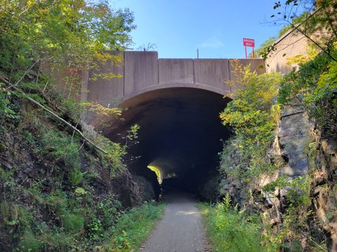
Bolton incorporated in October 1720, split off from Hartford, where the area had been known as the "Hartford Mountains" or "Hanover"; the town takes its name from Bolton, England, near Manchester. Its northern half was set off in 1808 to form Vernon. Quarrying drove Bolton's early economy: stone was cut at Quarryville, a small quarrying community near Bolton Notch, and hauled by oxcart to the Connecticut River for shipment to East Coast cities before the railroads arrived. In late June 1781, French troops under the Comte de Rochambeau camped in Bolton — French Camp Site Five on the march to join Washington's army — on ground now preserved as the town-owned Bolton Heritage Farm, formerly Valley View Farm. Library service began in 1881, growing from a corner of a general store into today's Bentley Memorial Library, built in 1975 and named for longtime librarian Elinor Hees Bentley.
-
sight
A 95-acre park around a mica-schist notch, with the Mohegan Trail and caves.
-
A rail-trail through Bolton, part of a 20-plus-mile corridor to Willimantic.
-
sight
The flagship store and headquarters of the Connecticut chocolate maker.
-
sight
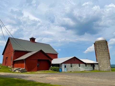
Site of Rochambeau's 1781 French encampment, Camp Site Five.
-
sight
Bolton's year-round town park with ball fields and winter skating.
-
Italian-American dining and banquet halls on US Route 44, open since 1992.
-
Neighborhood pizzeria and ice cream counter on West Street.
Quarries and Rochambeau's march
Before Bolton incorporated in October 1720, the area belonged to Hartford and was known as the "Hartford Mountains" or "Hanover." Its early economy centered on quarrying: stone was cut at Quarryville, a small quarrying settlement near Bolton Notch, and hauled by oxcart to the Connecticut River for shipment before the railroads arrived. In late June 1781, French troops under the Comte de Rochambeau camped in Bolton — French Camp Site Five on the Washington-Rochambeau Revolutionary Route — as four divisions passed through on successive days. That ground is preserved today as Bolton Heritage Farm, formerly Valley View Farm, which received a Connecticut Preservation Award for its recovery after an arsonist destroyed the historic barn complex in May 2015. Bolton's northern half was set off in 1808 to form the town of Vernon.
Getting there
Bolton sits about 15 miles east of Hartford at the eastern terminus of Interstate 384, which meets US Route 6 and US Route 44 in town. US Route 6 runs east-west through Bolton Notch toward Windham and the Quiet Corner; US Route 44 runs east-west through Bolton Center toward Coventry and Storrs; CT Route 85 runs north-south toward Hebron and Colchester. There is no passenger rail station in Bolton or anywhere in eastern Tolland County. The CTrail Hartford Line's nearest stop is Hartford Union Station, about 15 miles west, which also serves Amtrak; neither Metro-North's New Haven Line nor Shore Line East comes anywhere near Bolton.
Where to eat and stay
Bolton's dining runs along US Route 44: Georgina's Restaurant & Banquets has served Italian-American food since 1992, and Parkside Pizza & Ice Cream pairs a pizzeria with an ice cream counter. No hotel, motel, inn or bed-and-breakfast could be verified operating within Bolton itself; travelers should expect to base in the Manchester or Vernon hotel corridor roughly 6-10 miles west along I-384 and I-84, though no specific property there is confirmed in this research.
Frequently asked questions
- How do I get to Bolton?
- By car — Interstate 384 ends in Bolton at the US Route 6/US Route 44 junction. There is no passenger rail station in Bolton; the nearest CTrail Hartford Line stop, also served by Amtrak, is Hartford Union Station, about 15 miles west.
- Is there a train to Bolton?
- No. Bolton and eastern Tolland County have no passenger rail station. The closest service is the CTrail Hartford Line and Amtrak at Hartford Union Station, about 15 miles west.
- What is Bolton Notch State Park?
- A 95-acre park built around a natural notch eroded through mica-schist ledges, with the 1.7-mile Mohegan Trail climbing to views of the Connecticut River Valley, caves, and connections to the Shenipsit Trail and the Hop River State Park Trail. Open daily 8 a.m. to sunset, free admission.
- What is Bolton Heritage Farm?
- A town-owned farmstead, formerly Valley View Farm, where French troops under the Comte de Rochambeau camped in late June 1781 while marching to join Washington's army. It received a Connecticut Preservation Award for its recovery after an arsonist destroyed the historic barn complex in May 2015.
- Is there a hotel in Bolton?
- No hotel, motel, inn or bed-and-breakfast could be verified operating within Bolton. The nearest hotel corridor is in Manchester and Vernon, roughly 6-10 miles west along I-384 and I-84.
Foliage
Turning this week · estimated peak Oct 21–27
On the Yankee Roots foliage driving route.
Derived from the Connecticut DEEP fall foliage map. DEEP's map is a climatological estimate last published in 2023; it describes a normal year, not this one. Stage names are ours. See the statewide forecast.
Connected pages
Nearby
-
Coventry, Connecticut: Nathan Hale's Farm and a Glass Factory District
· Coventry, Connecticut
The two towns share a border
-
Hebron, Connecticut: A Rescued Family and a Ghost Mill Town
· Hebron, Connecticut
The two towns share a border
-
Glastonbury, Connecticut: The Oldest Ferry in America
· Glastonbury, Connecticut
The two towns share a border
-
Vernon, Connecticut: Rockville's Woolen-Mill Legacy
· Vernon, Connecticut
Bolton's northern half was set off in 1808 to form the town of Vernon.
-
Andover, Connecticut: A Man-Made Lake and Rochambeau's Route
· Andover, Connecticut
Andover borders Bolton to the southeast, reached via US Route 6.
-
Manchester, Connecticut: The Silk City's Mill Empire
· Manchester, Connecticut
Manchester borders Bolton to the east.
Shared history
-
Hebron, Connecticut: A Rescued Family and a Ghost Mill Town
· Hebron, Connecticut
Gay City State Park, a former Methodist mill village with a lakeside beach, spans the Bolton-Hebron line.
Same region
-
Coventry, Connecticut: Nathan Hale's Farm and a Glass Factory District
· Coventry, Connecticut
US Route 44 runs east-west through Bolton Center toward Coventry and Storrs.
-
Storrs, Connecticut: A Farm Gift Grows Into UConn
· Storrs, Connecticut
Both on the Yankee Roots foliage route
What travelers think
Log in to react.
No reviews yet.