
Kingsbridge, the Bronx: Broadway, Step Streets and a Buried Bridge
Kingsbridge, New York
Pictures from Kingsbridge
See all 1 photos →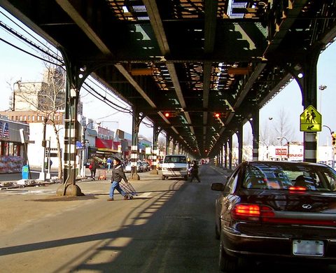
Kingsbridge is a Bronx neighborhood built along Broadway, where the elevated IRT Broadway–Seventh Avenue Line runs above the street and the 1 train calls at the 231st Street and 238th Street stations. It is part of a business improvement district that is home to 200 merchants, which its own Wikipedia article calls one of the largest retail shopping districts in the Bronx, and Dominicans predominantly live along Broadway and adjacent side streets. Step streets between Riverdale and Kingsbridge climb as many as 160 steps. Fort Independence Park/Playground and Old Fort Four Park/Playground, both on Sedgwick Avenue, carry the names of Revolutionary War forts. The neighborhood itself is named for the King's Bridge, likely erected by enslaved Africans in 1693 and owned by Frederick Philipse, lord of Philipsburg Manor. The bridge is said to still be in place, buried when the creek bed was filled in. Kingsbridge is in Bronx Community Board 8, and its ZIP code is 10463.
-
A business improvement district home to 200 merchants, under the elevated IRT Broadway–Seventh Avenue Line and its 231st Street and 238th Street stations.
-
sight
Built in 1693 by Frederick Philipse near what is now West 230th Street, and said to still be in place, buried when the creek bed was filled in.
-
Sedgwick Avenue and Giles Place. Its stone wall is the only extant physical trace of the fort the Continental Army built in 1776.
-
2890 Sedgwick Avenue, named for Fort Number Four, the largest of eight outer defenses built by the Continental Army in 1777.
-
sight
3021 Kingsbridge Avenue. Tudor Revival, by Davis, McGrath & Kiessling, completed in 1904 and designated a New York City Landmark on February 19, 1974.
-
sight
The Visitation Roman Catholic Church and School, on West 239th Street in northern Kingsbridge, and St. John's merger partner from November 2, 2014.
-
sight
291 West 231st Street. Its 1905 Carnegie building at 3041 Kingsbridge Avenue, by McKim, Mead & White, is now the Spuyten Duyvil Preschool.
Broadway and the streets off it
Kingsbridge is part of a business improvement district that is home to 200 merchants, which the neighborhood's own Wikipedia article calls one of the largest retail shopping districts in the Bronx, and Dominicans predominantly live along Broadway and adjacent side streets. The elevated IRT Broadway–Seventh Avenue Line runs directly above it, carrying both the 231st Street and 238th Street stations.
Off the avenue, the Kingsbridge Library is at 291 West 231st Street. The Church of St. John stands at 3021 Kingsbridge Avenue, and the Visitation Roman Catholic Church and School is on West 239th Street, in northern Kingsbridge. Fort Independence Park/Playground is at Sedgwick Avenue and Giles Place, stretching along part of Sedgwick Avenue with handball courts, a basketball court and a playground; Old Fort Four Park/Playground is on the same avenue, at 2890 Sedgwick Avenue. On 233rd Street and Bailey Avenue there is a baseball field run by Kingsbridge Little League, with lights, dugouts, stands and a small food court. The NYPD's 50th Precinct polices the neighborhood from 3450 Kingsbridge Avenue, and fire coverage comes from Engine Co. 81/Ladder Co. 46 at 3025 Bailey Avenue.
The neighborhood's boundaries are Manhattan College Parkway to the north, the Major Deegan Expressway or Bailey Avenue to the east, West 230th Street to the south, and Irwin Avenue to the west. Kingsbridge is part of Bronx Community Board 8, and its ZIP code is 10463. The 2010 census counted Kingsbridge and Spuyten Duyvil together at 30,161, a change of 289 (1%) from the 29,872 counted in 2000; that combined count was 49.3% White, 33.8% Hispanic or Latino, 8.9% African American and 5.7% Asian.
The King's Bridge, the forts and the parish
In 1693 Frederick Philipse, lord of Philipsburg Manor, built the King's Bridge at Marble Hill near what is now West 230th Street. It was likely erected by enslaved Africans, and it spanned a now-filled-in section of Spuyten Duyvil Creek, roughly parallel to today's 230th Street. The bridge is said to still be in place, having been buried when the creek bed was filled in. After the American Revolution, Philipse Manor was forfeited to the state legislature, after which the King's Bridge was free of tolls. The area was part of the Town of Kingsbridge until New York City annexed it in 1874, as part of three towns that became the Bronx's western half.
For most of the American Revolutionary War, the area was under British control. A stone wall in Fort Independence Park/Playground, on Sedgwick Avenue and Giles Place, is the only extant physical trace of Fort Independence, built by the Continental Army in 1776. On January 18–28, 1777, an American force led by General William Heath unsuccessfully attempted to recapture it. Old Fort Four Park/Playground, at 2890 Sedgwick Avenue, is named for Fort Number Four, the largest in a series of eight outer defenses built by the Continental Army in 1777.
The Church of St. John, at 3021 Kingsbridge Avenue, is a Roman Catholic parish church under the Archdiocese of New York, Tudor Revival, by the architects Davis, McGrath & Kiessling. The property was purchased in 1870, and the first church was dedicated by Cardinal McCloskey on December 4, 1877; that structure was demolished in 1893, work on the present church's basement began the same year, and the present church was completed in 1904. Above the altar hangs a copy of Brumidi's "Crucifixion," and the basement contains a chapel, hall, theater, club-rooms and a gymnasium. The church was designated a New York City Landmark on February 19, 1974, and on November 2, 2014 the parish merged with the Church of the Visitation.
The Kingsbridge Library's Carnegie building at 3041 Kingsbridge Avenue, designed by McKim, Mead & White, opened on May 19, 1905; the branch outgrew that building and closed it in 1958, and it is now the Spuyten Duyvil Preschool. The branch's current address is 291 West 231st Street.
Getting there
The 231st Street and 238th Street stations both sit in Kingsbridge, elevated on Broadway on the IRT Broadway–Seventh Avenue Line, each with two side platforms. The 1 serves each of them at all times. The 231st Street station opened on January 27, 1907 as the "230th Street station"; the 238th Street station opened on August 1, 1908.
No Metro-North station sits inside Kingsbridge. The nearest is Marble Hill, on the Hudson Line, at 125 West 225th Street — an address in Marble Hill, Manhattan, not the Bronx. Before the Harlem River Ship Canal was cut, the nearest station was a station in the Bronx named Kingsbridge.
Several bus routes run through or terminate here. The Bx1 runs between Mott Haven – 138th Street and Riverdale – 231st Street, via the Grand Concourse, Sedgwick Avenue and Mosholu Parkway, terminating at the 231st Street station; the Bx2 runs between Kingsbridge Heights – Fort Independence Street and Mott Haven, and some weekday-southbound and Sunday-morning trips serve the 231st Street station. The Bx7 runs from St. Nicholas Avenue and West 167th Street in Washington Heights to Riverdale Avenue and West 263rd Street in Riverdale, via Broadway and Riverdale Avenue. The Bx9 runs from Broadway and West 262nd Street in Riverdale to Tremont Avenue and Boston Road in West Farms, via Broadway, Kingsbridge Road, Fordham Road and Southern Boulevard. The Bx10 runs from East 206th Street and Bainbridge Avenue in Norwood to Riverdale Avenue and West 263rd Street, via Jerome Avenue, Bailey Avenue, West 231st Street and Riverdale Avenue. The Bx20, weekday rush hours only, runs from Broadway and Isham Street in Inwood to the Henry Hudson Parkway and West 246th Street in Riverdale, via Broadway, Johnson Avenue and the Henry Hudson Parkway.
By road and rail from Manhattan, Broadway crosses the Harlem River on the Broadway Bridge, a double-deck vertical-lift structure built between 1957 and 1962, carrying Broadway and US Route 9 on its lower deck and the 1 train on its upper deck; the bridge itself is entirely in Manhattan.
Frequently asked questions
- How do I get to Kingsbridge?
- By subway, the 1 serves the neighborhood's stations at all times: 231st Street, which opened on January 27, 1907 as the "230th Street station," and 238th Street, which opened on August 1, 1908. Both are elevated on Broadway on the IRT Broadway–Seventh Avenue Line. No Metro-North station sits inside Kingsbridge; the nearest is Marble Hill on the Hudson Line, at 125 West 225th Street, in Marble Hill, Manhattan. By bus, the Bx1, Bx2, Bx7, Bx9, Bx10 and the weekday rush-hour Bx20 run through or terminate here, with the Bx1 terminating at the 231st Street station.
- Why is it called Kingsbridge?
- The neighborhood is named for the King's Bridge, likely erected by enslaved Africans in 1693 and owned by Frederick Philipse, lord of Philipsburg Manor. Philipse built it at Marble Hill near what is now West 230th Street, spanning a section of Spuyten Duyvil Creek that has since been filled in, roughly parallel to today's 230th Street. The historic Town of Kingsbridge, which New York City annexed in 1874, carried the same name.
- Is the King's Bridge still there?
- The bridge is said to still be in place, having been buried when the creek bed was filled in. It is not standing above ground: the section of Spuyten Duyvil Creek it crossed no longer exists. Tolls on it ended after the American Revolution, when Philipse Manor was forfeited to the state legislature.
- What is left of the Revolutionary War forts?
- A stone wall in Fort Independence Park/Playground, at Sedgwick Avenue and Giles Place, is the only extant physical trace of Fort Independence, built by the Continental Army in 1776. An American force under General William Heath tried and failed to recapture the fort on January 18–28, 1777. Old Fort Four Park/Playground, at 2890 Sedgwick Avenue, keeps the name of Fort Number Four, the largest in a series of eight outer defenses the Continental Army built in 1777.
- Where is the Kingsbridge Library?
- At 291 West 231st Street. The branch has served the neighborhood since 1905. Its original Carnegie building, at 3041 Kingsbridge Avenue, was designed by McKim, Mead & White and opened on May 19, 1905; the branch outgrew it and closed it in 1958, and that building is now the Spuyten Duyvil Preschool.
Connected pages
Shared history
-
Riverdale, the Bronx: High Ground and Disputed Borders
· Riverdale, New York
Riverdale and Kingsbridge were both part of the Town of Yonkers until the later 19th century, and Kingsbridge adjoins Riverdale on the southeast.
Same region
-
Riverdale, the Bronx: High Ground and Disputed Borders
· Riverdale, New York
Step streets, some with up to 160 steps, climb between Kingsbridge and Riverdale. Kingsbridge's northern boundary is Manhattan College Parkway.
-
Mott Haven, the Bronx: Alexander Avenue and St. Ann's Church
· Mott Haven, New York
The Bx1 bus runs between Mott Haven and Kingsbridge's 231st Street station, by way of the Grand Concourse and Sedgwick Avenue.
What travelers think
Log in to react.
No reviews yet.