
Mott Haven, the Bronx: Alexander Avenue and St. Ann's Church
Mott Haven, New York
Pictures from Mott Haven
See all 1 photos →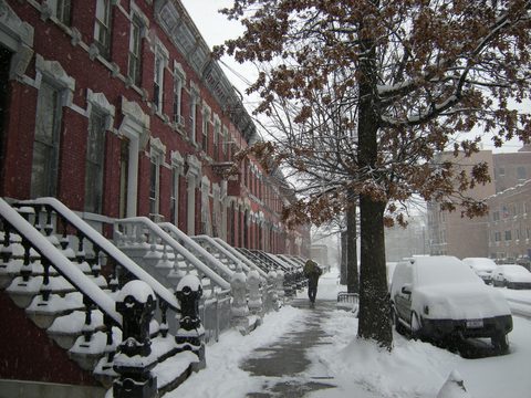
Mott Haven stands on ground the Dutch West India Company purchased from the Wecquaesgeek in 1639. Jonas Bronck farmed here at a place called Emmanus, near what is now Willis Avenue and 132nd Street, and the peace treaty with the chiefs Ranaqua and Tackamuck was signed in his house. He lived in the area only four years, but the land became known as Broncksland, and the Morris family bought it in 1670. Jordan Lawrence Mott purchased the land for his iron works in 1849; a vestige of those works can be seen west of the Third Avenue Bridge on East 134th Street. Wikipedia gives the bounds as East 149th Street to the north, the Bruckner Expressway to the east and south and the Harlem River to the west, adding that these boundaries are not precise. The neighborhood is part of Bronx Community Board 1.
-
Alexander Avenue between East 138th and East 141st Streets: 11 acres of nineteenth-century row houses, landmarked July 29, 1969.
-
East 139th and East 140th Streets between Brook and Willis Avenues, designed by William O'Gorman and William Hornum in 1883.
-
East 136th Street between Brook and Willis Avenues, designed by Edward Bertine between 1891 and 1895.
-
295 St. Ann's Avenue. Built 1841, dedicated to Gouverneur Morris's mother Ann; Gouverneur and Lewis Morris are both buried here.
-
558 Grand Concourse. Thomas Harlan Ellett's building holds thirteen mural panels by Ben Shahn and Bernarda Bryson, completed August 1939.
-
sight
321 East 140th Street, open to the public since 1905 and standing inside the Mott Haven Historic District.
-
walk
35.31 acres named for Adrian Janes's daughter Mary. The borough's first playground opened here in 1914.
-
food
The brewery's own site names a Bronx location and a second at Hudson Yards in Manhattan.
Broncksland, the Motts, and the North Side
East 138th Street is the primary east–west thoroughfare through Mott Haven. The neighborhood was a mixed German-American and Irish-American one, the German households north of East 145th Street and the Irish south of it. The Star of Munster Ballroom was at the northeast corner of Willis Avenue and East 138th Street. Irish Republican Army veterans organized a large parade here in the late 1940s or early 1950s.
The first Puerto Rican settlements came in the late 1940s, along the length of Brook Avenue.
Before the term "South Bronx" emerged, the area was known as "the North Side" or "North New York." Wikipedia attributes that older naming to Mott Haven together with Port Morris rather than to Mott Haven alone, and this page does not claim it for one neighborhood. A trace of it survives in a building: the Chase Manhattan Bank building at Third Avenue and East 137th Street was originally the North Side Board of Trade Building, of 1912.
Wikipedia gives the neighborhood a 2020 population of 54,163 residents over an area of 1.180 square miles.
Alexander Avenue and the landmarked blocks
Three historic districts carry New York City Landmark designations here. The Mott Haven Historic District runs along Alexander Avenue between East 138th and East 141st Streets, 11 acres of four- and five-story row houses from the last half of the nineteenth century in Gothic, Queen Anne and Romanesque styles; some of its row houses were known historically as "Doctors' Row" and "Irish Fifth Avenue." It was designated on July 29, 1969 and listed on the National Register of Historic Places on March 25, 1980. Two more were designated on the same day, April 5, 1994: the Mott Haven East Historic District on East 139th and East 140th Streets between Brook and Willis Avenues, designed by William O'Gorman and William Hornum in 1883, and the Bertine Block Historic District on East 136th Street between Brook and Willis Avenues, designed by Edward Bertine between 1891 and 1895.
The Mott Haven district takes in two institutions and a police station: the 1905 Mott Haven Branch of the New York Public Library, Saint Jerome's Roman Catholic Church, and the 40th Precinct. That matters for how the library's landmark status is described. NYPL's own page says the branch was declared a landmark in 1969, and the boroughwide landmarks list carries no separate entry for the library — so what the building holds is the district's July 29, 1969 designation, not an individual landmarking of its own.
St. Ann's Church and Graveyard was designated an individual landmark earlier still, on June 9, 1967. Built in 1841 and dedicated to Gouverneur Morris's mother, Ann, it holds the graves of Gouverneur Morris and of Lewis Morris, a signer of the Declaration of Independence. Wikipedia's Mott Haven article calls it the Bronx's oldest church; that is the article's own characterization.
The Bronx General Post Office at 558 Grand Concourse carries two designations, exterior and interior. One more designation covers a building nobody visits: the firehouse at 341 East 143rd Street, which houses Engine Company 60, Ladder Company 17 and Battalion 14, was designated on June 20, 2000. It is a working firehouse and is not written up here as a place to go.
Getting there
The IRT Pelham Line, carrying the 6 and <6>, runs along East 138th Street.
Wikipedia's Mott Haven article names seven subway stations for the neighborhood: 138th Street–Grand Concourse on the 4 and 5; Third Avenue–138th Street on the 6 and <6>; Brook Avenue, Cypress Avenue and East 143rd Street–St. Mary's Street on the 6; 149th Street–Grand Concourse on the 2, 4 and 5; and Third Avenue–149th Street on the 2 and 5. The article lists them without saying where any of them physically sits, and East 149th Street is the neighborhood's own stated northern boundary, so the last two are on that line and no station here is described as being inside Mott Haven.
For Metro-North the article names Harlem–125th Street and Yankees–East 153rd Street as the closest stops. Neither is in the neighborhood: Harlem–125th Street is in Manhattan, and Yankees–East 153rd Street is north of the boundary Wikipedia gives.
The bus routes the article lists for Mott Haven are the Bx1, Bx2, Bx4, Bx17, Bx19, Bx21, Bx32, Bx33, Bx41 and the M125.
This page does not name an NYC Ferry landing for Mott Haven.
Five bridges are named as serving the neighborhood: the Triborough, Third Avenue, Madison Avenue, 145th Street and Willis Avenue bridges. The Third Avenue Bridge is a swing bridge over the Harlem River between Manhattan and the Bronx and carries southbound, Bronx-to-Manhattan traffic. It opened on August 1, 1898 and was converted to one-way southbound operation on August 5, 1941. The original span was removed in 1955 and the rebuilt bridge reopened in December 1956; a reconstruction ran from 2001 to 2005, with the new swing span floated into place on October 29, 2004.
Frequently asked questions
- How do I get to Mott Haven?
- By subway, most obviously: the IRT Pelham Line, carrying the 6 and <6>, runs along East 138th Street, and Wikipedia's Mott Haven article names 138th Street–Grand Concourse (4, 5), Third Avenue–138th Street (6, <6>), Brook Avenue (6), Cypress Avenue (6), East 143rd Street–St. Mary's Street (6), 149th Street–Grand Concourse (2, 4, 5) and Third Avenue–149th Street (2, 5) for the neighborhood. The article does not say where each station sits, and the two 149th Street stations stand on East 149th Street, which is the neighborhood's own stated northern boundary, so none is called a Mott Haven station here. The closest Metro-North stops are Harlem–125th Street, in Manhattan, and Yankees–East 153rd Street, north of the boundary. The buses listed are the Bx1, Bx2, Bx4, Bx17, Bx19, Bx21, Bx32, Bx33, Bx41 and M125. This page does not name a ferry landing for Mott Haven.
- Why is it called Mott Haven?
- Jordan Lawrence Mott purchased the land for his iron works in 1849, and the neighborhood carries his name. A vestige of the iron works can be seen west of the Third Avenue Bridge on East 134th Street. Before that the ground was Broncksland, after Jonas Bronck, who farmed at Emmanus near what is now Willis Avenue and 132nd Street and lived in the area only four years.
- Which historic districts are in Mott Haven?
- Three. The Mott Haven Historic District on Alexander Avenue between East 138th and East 141st Streets, 11 acres, designated a New York City Landmark on July 29, 1969 and listed on the National Register of Historic Places on March 25, 1980. The Mott Haven East Historic District on East 139th and East 140th Streets between Brook and Willis Avenues, designed by William O'Gorman and William Hornum in 1883 and designated April 5, 1994. And the Bertine Block Historic District on East 136th Street between Brook and Willis Avenues, designed by Edward Bertine between 1891 and 1895 and designated on the same day.
- Is the Bronx General Post Office still a post office?
- This page does not say what the building holds today. Mail processing operations relocated out of 558 Grand Concourse in 2011. The building was sold to Youngwoo & Associates in September 2014 for $19 million, resold to Maddd Equities in July 2025 for $44 million, and a CUNY lease was signed in September 2025. The exterior was designated a New York City Landmark on September 14, 1976 and the interior on December 17, 2013, so the building is protected whatever it holds.
- Where can I stay in Mott Haven?
- Nothing is listed here, and that is a gap rather than a finding. The Opera House Hotel at 436 East 149th Street sits on the street Wikipedia gives as Mott Haven's northern boundary — but Wikipedia's own article on the Bronx Opera House building states the neighborhood as Melrose, in plain terms, so the hotel belongs to that neighborhood's page rather than this one. Proximity to a boundary does not override a sourced neighborhood assignment.
Connected pages
Same region
-
Concourse, the Bronx: The Grand Concourse and Its Historic District
· Concourse, New York
The Bronx General Post Office, built in 1935 and opened in 1937, stands at 558 Grand Concourse.
-
Hunts Point, the Bronx: Food Markets, Waterfront Parks and THE POINT
· Hunts Point, New York
Another Bronx neighborhood covered in this series.
-
Kingsbridge, the Bronx: Broadway, Step Streets and a Buried Bridge
· Kingsbridge, New York
The Bx1 bus runs between Mott Haven and Kingsbridge's 231st Street station, by way of the Grand Concourse and Sedgwick Avenue.
See also
-
Morris Park, the Bronx: Racecourse Lots and Hospital Campuses
· Morris Park, New York
The Bx21 bus runs from Mott Haven to Westchester Square, with Morris Park Avenue among its primary streets.
What travelers think
Log in to react.
No reviews yet.