
Riverdale, the Bronx: High Ground and Disputed Borders
Riverdale, New York
Pictures from Riverdale
See all 1 photos →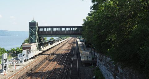
Riverdale occupies the northwestern corner of the Bronx, bordered by Yonkers to the north, Van Cortlandt Park and Broadway to the east, the Kingsbridge neighborhood to the southeast, either the Harlem River or the Spuyten Duyvil neighborhood to the south, and the Hudson River to the west. Riverdale's boundaries are disputed, and its eastern and southern boundaries are frequently disputed. It sits at a high elevation, and its views take in the Empire State Building, the George Washington Bridge, the Hudson River and the New Jersey Palisades. Riverdale, Kingsbridge and other northwest Bronx areas were part of the Town of Yonkers until the later 19th century. ZIP codes 10463 and 10471 cover the neighborhood: 10471 lies entirely in Riverdale, while 10463 also covers the adjacent neighborhoods of Kingsbridge, Bronx, and Marble Hill, Manhattan.
-
sight
A 28-acre estate at West 249th Street and Independence Avenue, now public horticultural gardens and a cultural center with two houses and a botanical garden.
-
walk
Approximately 1.5 miles along the Hudson River and one block wide, following Palisade Avenue, with an entrance at Dodge Lane (247th Street).
-
Fifteen acres in the northwest of the neighborhood, designated on October 16, 1990.
-
W. 261st St. and Riverdale Ave. Its campus holds Fonthill Castle, built in 1852 and landmarked on March 15, 1966, and New York City's northernmost point.
-
sight
5040 Henry Hudson Parkway East. High Victorian Gothic, built in 1866 by Richard M. Upjohn, and landmarked on January 11, 1967.
-
4761-4765 Henry Hudson Parkway. Built in 1863-64 by James Renwick Jr., with a later enlargement in 1936 credited to Dwight James Baum.
-
sight
The memorial bell tower in Bell Tower Park, dated September 17, 1930 and built by Dwight James Baum; its plaque lists World War I servicemembers.
-
sight
690 W. 247th St., listed on the National Register of Historic Places on August 28, 1977.
-
sight
5225 Sycamore Ave. in Hudson Hill, listed on the National Register of Historic Places on September 8, 1983.
The subsections, the river edge and the landmarked blocks
Riverdale is divided into subsections. Fieldston lies south of West 250th Street, east of the Henry Hudson Parkway, north of Manhattan College Parkway and west of Tibbett Avenue. Hudson Hill is above West 246th Street and west of the Henry Hudson Parkway; North Riverdale is above West 254th Street and west of Fieldston Road; Mosholu is east of Fieldston Road and above West 254th Street; Central Riverdale runs from Manhattan College Parkway to West 232nd Street; Villanova Heights is bounded by Fieldston Road, 250th Street and the Henry Hudson Parkway. Spuyten Duyvil, or South Riverdale, lies below West 232nd Street or West 239th Street, by some definitions.
Wave Hill is a 28-acre estate in the Hudson Hill section, at West 249th Street and Independence Avenue. It currently consists of public horticultural gardens and a cultural center, with two houses and a botanical garden, and on an annual basis about 65,000 people visit it. Adjacent to its grounds, Riverdale Park runs along the Hudson River for approximately 1.5 miles (2.4 km), one block wide, averaging 9 metres above sea level. The park follows Palisade Avenue between 254th Street and 232nd Street, with an entrance at Dodge Lane (247th Street), and its main sections from north to south are The North Woods, The Fishing Trail, Dodge Lane, The Oak Forest and the South End.
Christ Church Riverdale, High Victorian Gothic and built in 1866 by Richard M. Upjohn of Upjohn & Co., stands at 5040 Henry Hudson Parkway East. The Riverdale Presbyterian Church Complex, built in 1863-64 by James Renwick Jr., is at 4761-4765 Henry Hudson Parkway. The Riverdale Historic District, 15 acres in the northwest of the neighborhood, was designated on October 16, 1990. The William E. Dodge House stands at 690 W. 247th St. and the Robert Colgate House at 5225 Sycamore Ave. in Hudson Hill.
At Riverdale Avenue at W. 239th St. and Henry Hudson Pkwy., the Riverdale–Spuyten Duyvil–Kingsbridge Memorial Bell Tower — commonly the Riverdale Monument — stands in Bell Tower Park, its plaque listing World War I servicemembers from Riverdale and neighboring areas. The campus of the University of Mount Saint Vincent, at W. 261st St. and Riverdale Ave., holds Fonthill Castle; the northernmost point in New York City is at the Hudson River on that campus.
Yonkers, Fieldston and the estates
Riverdale, Kingsbridge and other northwest Bronx areas were part of the Town of Yonkers until the later 19th century.
Fieldston — the subsection south of West 250th Street, east of the Henry Hudson Parkway, north of Manhattan College Parkway and west of Tibbett Avenue — has a development history of its own. A Delafield purchase of 250 acres in 1829 gave Fieldston its name, taken from the family's Irish estate. Lots were laid out in 1909, following the extension of the IRT subway to Van Cortlandt Park–242nd Street in 1908, and Albert E. Wheeler designed Fieldston's streets to follow the land's contours. The first house was begun in 1910 and finished in 1911. In 1923, after 80 houses were completed, the Fieldston Property Owners' Association formed; it still owns Fieldston's streets and common areas, plows the streets, does sewer repair and cares for the trees. In 1938 the New York City Planning Commission approved a special zoning district there prohibiting multiple-family buildings.
The original Wave Hill House was a gray fieldstone mansion built in 1843 by William Lewis Morris. William Henry Appleton owned the estate from 1866 to 1903, enlarging the house between 1866 and 1869 and again in 1890, and George Walbridge Perkins, a partner of J. P. Morgan, purchased it in 1903. In 1960 the Perkins-Freeman family deeded Wave Hill to the City of New York. Huxley visited; the Roosevelts rented the estate in 1870 and 1871; Twain leased it from 1901 to 1903; and Toscanini lived there from 1942 to 1945.
Fonthill Castle was built in 1852 for Edwin Forrest and Catherine Norton Sinclair, a Gothic Revival cluster of six octagonal towers in hammered grey stone, its name taken from William Beckford's Fonthill Abbey. The Sisters of Charity of New York relocated the Academy of Mount Saint Vincent from McGowan's Pass to the property; that academy, founded in 1847 as a school for women, became degree-granting and took the College name in 1911, and was renamed the University of Mount Saint Vincent in 2024.
Riverdale Park was originally planned as a neighborhood centerpiece but remained undeveloped. In the 1940s the Delafield, Dodge, Douglas and Perkins families donated land to New York City with a requirement that it be kept natural, and the land was established as a special natural area in the 1950s. Wave Hill created a Learning Center connected to the park in 1981, began the Riverdale Park Project in 1983 and developed a Natural Sciences Program in 1984 — forest-management and ecological-education programs run by Wave Hill.
The Riverdale Monument was built by the architect Dwight James Baum and is dated September 17, 1930. It was moved 700 feet south from its original site in 1936 to make room for the Henry Hudson Parkway.
Getting there
Van Cortlandt Park–242nd Street is the northern terminal station of the IRT Broadway–Seventh Avenue Line, served by the 1 at all times. It serves Fieldston, Kingsbridge and Riverdale, and stands on the border of Fieldston and Kingsbridge. It opened on August 1, 1908 to a design by Heins & LaFarge, is the only remaining Victorian Gothic elevated terminal station on the subway, and was listed on the National Register of Historic Places in 2005.
Metro-North's Hudson Line serves Riverdale at Riverdale station, between West 254th and 255th Streets, and at Spuyten Duyvil station, at Edsall Avenue. Riverdale station — also known as Riverdale–West 254th Street station, at Railroad Terrace and West 254th Street — is the northernmost Metro-North station in New York City on the Hudson Line. Spuyten Duyvil station is located in the Spuyten Duyvil neighborhood of the Bronx.
The Bx1, Bx7, Bx9, Bx10, Bx20, BxM1-3 and BxM18 buses serve the area, along with Bee-Line routes to Westchester County.
The 2011 Comprehensive Citywide Ferry Study identified potential ferry routes to western Manhattan and Riverdale, which were not implemented.
Frequently asked questions
- How do I get to Riverdale?
- By subway, Van Cortlandt Park–242nd Street is the northern terminal station of the IRT Broadway–Seventh Avenue Line, served by the 1 at all times, serving Fieldston, Kingsbridge and Riverdale. Metro-North's Hudson Line serves the neighborhood at Riverdale station, between West 254th and 255th Streets, and at Spuyten Duyvil station, at Edsall Avenue — though Spuyten Duyvil station is located in the Spuyten Duyvil neighborhood of the Bronx. By bus, the Bx1, Bx7, Bx9, Bx10, Bx20, BxM1-3 and BxM18 serve the area, along with Bee-Line routes to Westchester County. The 2011 Comprehensive Citywide Ferry Study identified potential ferry routes to western Manhattan and Riverdale, which were not implemented.
- Where does Riverdale begin and end?
- Riverdale's boundaries are disputed, and its eastern and southern boundaries are frequently disputed. It is bordered by Yonkers to the north, Van Cortlandt Park and Broadway to the east, the Kingsbridge neighborhood to the southeast, either the Harlem River or the Spuyten Duyvil neighborhood to the south, and the Hudson River to the west. Its subsections are Fieldston, Hudson Hill, North Riverdale, Mosholu, Central Riverdale, Spuyten Duyvil or South Riverdale, and Villanova Heights.
- What is Wave Hill?
- A 28-acre estate in the Hudson Hill section of Riverdale, at West 249th Street and Independence Avenue, which currently consists of public horticultural gardens and a cultural center with two houses and a botanical garden. About 65,000 people visit on an annual basis. The original Wave Hill House was a gray fieldstone mansion built in 1843 by William Lewis Morris; George Walbridge Perkins, a partner of J. P. Morgan, bought the estate in 1903, and the Perkins-Freeman family deeded it to the City of New York in 1960. It was added to the National Register of Historic Places in 1983, and Wave Hill House was designated a New York City Landmark on June 21, 1966.
- What is Fonthill Castle?
- A Gothic Revival building on the campus of the University of Mount Saint Vincent at W. 261st St. and Riverdale Ave., built in 1852 for Edwin Forrest and Catherine Norton Sinclair as a cluster of six octagonal towers in hammered grey stone, named after William Beckford's Fonthill Abbey. Its design has been attributed to Alexander Jackson Davis and also to Thomas C. Smith. The castle has served as a convent, chapel, museum, chaplain's residence and the college library, and later housed the admissions office. It held the library from 1942 to 1968 and is currently vacant.
- Which Riverdale buildings and districts are landmarked?
- The Riverdale Historic District, 15 acres in the northwest of the neighborhood, was designated on October 16, 1990. Wave Hill House was designated a New York City Landmark on June 21, 1966 and Wave Hill was added to the National Register of Historic Places in 1983. Fonthill Castle was designated on March 15, 1966 and National Register-listed on July 11, 1980. Riverdale Presbyterian Church was designated on April 19, 1966 and listed on October 14, 1982; Christ Church on January 11, 1967 and listed on September 8, 1983. The William E. Dodge House was listed on August 28, 1977, the Robert Colgate House on September 8, 1983, and the Riverdale Monument on January 3, 2012.
Connected pages
Shared history
-
Kingsbridge, the Bronx: Broadway, Step Streets and a Buried Bridge
· Kingsbridge, New York
Riverdale and Kingsbridge were both part of the Town of Yonkers until the later 19th century, and Kingsbridge adjoins Riverdale on the southeast.
Same region
-
Van Cortlandt Park, the Bronx: 1,146 Acres, Public Golf and a 1748 House
· Van Cortlandt Park, New York
Van Cortlandt Park and Broadway form the eastern boundary of Riverdale.
-
Kingsbridge, the Bronx: Broadway, Step Streets and a Buried Bridge
· Kingsbridge, New York
Step streets, some with up to 160 steps, climb between Kingsbridge and Riverdale. Kingsbridge's northern boundary is Manhattan College Parkway.
-
Steakhouses in Manhattan: Twenty-Three Rooms on the Midtown Spine
· Manhattan Steakhouses, New York
Jake's Steakhouse, Arnauld's Steak & Seafood and Riverdale Steak House are the Bronx's one real cluster, all three in Riverdale.
What travelers think
Log in to react.
No reviews yet.