
Long Island City, Queens: the East River Waterfront, Vernon Boulevard and Court Square
Long Island City, New York
Pictures from Long Island City
See all 1 photos →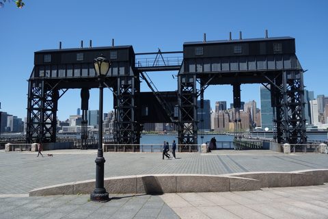
Long Island City lies on the Queens side of the East River. NYC Parks records that Dutch Kills joined Astoria Village, Hunter's Point, Ravenswood, Middletown and Blissville to form Long Island City in 1870, and the neighborhood spans Community Boards 1 and 2, north and south of Queens Plaza. Socrates Sculpture Park is at 32-01 Vernon Boulevard, the Noguchi Museum at 9-01 33rd Road and Gantry Plaza State Park at 4-44 47th Road; Hunter's Point South Park runs along Center Boulevard between 50th Avenue and 2nd Street, and Rainey Park covers 8.09 acres in ZIP 11106. MoMA PS1 is at 22-25 Jackson Avenue and SculptureCenter at 44-19 Purves Street. The Pepsi-Cola Sign, the Bank of the Manhattan Company Building and the Court Square courthouse carry Landmarks Preservation Commission designations, and the Hunters Point Historic District runs along 45th Avenue between 21st and 23rd Streets. NYC Ferry's Long Island City landing is at 46th Avenue and Center Boulevard.
-
sight
22-25 Jackson Avenue, in a nineteenth-century public school building decommissioned as a public school in 1963. The exhibition Rooms opened there in 1976.
-
sight
9-01 33rd Road, at Vernon Boulevard, in a repurposed 1920s industrial building.
-
sight
44-19 Purves Street.
-
32-01 Vernon Boulevard, on the East River waterfront; 6.28 acres by NYC Parks' measure, under the park ID Q465.
-
4-44 47th Road, described by New York State Parks as a 12-acre riverside oasis.
-
Along Center Boulevard between 50th Avenue and 2nd Street.
-
walk
At 49th Avenue, 5th Street and Vernon Boulevard, on land NYC Parks records as taken by condemnation for the approach to the Pulaski Bridge.
-
walk
20.86 acres in ZIP 11101, assigned by NYC Parks to Community Boards 1 and 2 together.
-
walk
8.09 acres in ZIP 11106, named for Dr. Thomas Rainey (1824-1910), a resident of Ravenswood.
-
sight
2.76 acres in ZIP 11106, named after Ravenswood, which NYC Parks calls "the shoreside Long Island City neighborhood in which it resides."
-
sight
2.40 acres, ZIPs 11101 and 11106, carrying the name of one of the villages that formed Long Island City in 1870.
-
45th Avenue between 21st and 23rd Streets, designated by the Landmarks Preservation Commission.
-
sight
4-09 47th Road, a designated New York City landmark.
-
42-10 to 42-16 Vernon Boulevard, in what its designation report calls "the once rural Ravenswood area of Queens (now Long Island City)."
-
29-27 Queens Plaza North, placed by the Landmarks Preservation Commission in the Dutch Kills section of Long Island City.
-
25-10 Court Square, designated by the Landmarks Preservation Commission.
-
10-40 47th Avenue, also addressed as 10-38 to 10-40 47th Avenue.
-
11th Street and Bridge Plaza North and Bridge Plaza South. NYC DOT gives its total length including the approaches as 7,449 feet.
-
sight
Main lot at 42-22 22nd Street, east lot at 34-02 Starr Avenue.
-
The Queens Public Library branch at 37-44 21 Street, on (718) 752-3700.
-
food
45-30 23rd St.
-
sight
1040 Jackson Avenue. Its own directions give the address as one stop from Grand Central on the 7 train.
-
food
37-08 Queens Boulevard. Its own site offers tabletop grilling or chef-prepared dishes.
The waterfront and the art institutions
Socrates Sculpture Park is at 32-01 Vernon Boulevard, Long Island City, NY 11106, and NYC Parks lists it at 6.28 acres under the park ID Q465. The Noguchi Museum is at 9-01 33rd Road, at Vernon Boulevard, in a repurposed 1920s industrial building. Rainey Park covers 8.09 acres in ZIP 11106, under the park ID Q048; NYC Parks records that the project was backed by citizens of Long Island City, and that the park carries the name of Dr. Thomas Rainey (1824-1910), a resident of Ravenswood. NYC Parks also records that the Queens East River and North Shore Greenway, completed in portions in 2013, linked Queens waterfront parks including Queensbridge Park, Rainey Park and Socrates Sculpture Park.
Queensbridge Park covers 20.86 acres in ZIP 11101, and NYC Parks assigns it to Community Boards 1 and 2 together. South of Queens Plaza, Gantry Plaza State Park is at 4-44 47th Road, and New York State Parks describes it as a 12-acre riverside oasis. Hunter's Point South Park runs along Center Boulevard between 50th Avenue and 2nd Street. Andrews Grove sits at the intersection of 49th Avenue, 5th Street and Vernon Boulevard, on land NYC Parks records as acquired by condemnation for the approach to the Pulaski Bridge.
MoMA PS1 is at 22-25 Jackson Avenue, in a historic nineteenth-century public school building that was decommissioned as a public school in 1963. The exhibition Rooms opened there in 1976, and the institution became an affiliate of the Museum of Modern Art in 2000; its Warm Up series began in 1998, and its Young Architects Program ran from 1999 to 2019. SculptureCenter is at 44-19 Purves Street.
Ravenswood, Dutch Kills and Court Square
NYC Parks records that Dutch Kills joined Astoria Village, Hunter's Point, Ravenswood, Middletown and Blissville to form Long Island City in 1870, and the Landmarks Preservation Commission's report on the Court Square courthouse dates the state legislature's approval of the area's incorporation as a township to May 6 of that year. Ravenswood Playground, 2.76 acres in ZIP 11106, is named after Ravenswood, which NYC Parks calls "the shoreside Long Island City neighborhood in which it resides." Dutch Kills Playground covers 2.40 acres and carries ZIPs 11101 and 11106. The Landmarks Preservation Commission's report on the New York Architectural Terra Cotta Works Building, at 42-10 to 42-16 Vernon Boulevard, places that building in what it calls "the once rural Ravenswood area of Queens (now Long Island City)."
On Queens Plaza, the Bank of the Manhattan Company Building stands at 29-27 Queens Plaza North, also addressed as 29-27 41st Avenue and 29-39 Northern Blvd; the Landmarks Preservation Commission places it in the Dutch Kills section of Long Island City. The New York State Supreme Court's Queens County, Long Island City branch is at 25-10 Court Square. Silvercup Studios keeps its main lot at 42-22 22nd Street and its east lot at 34-02 Starr Avenue.
South of the plaza, the Hunters Point Historic District runs along 45th Avenue between 21st and 23rd Streets, and the Pepsi-Cola Sign stands at 4-09 47th Road. The firehouse of Fire Engine Co. 258 and Hook & Ladder 115 is at 10-40 47th Avenue, also addressed as 10-38 to 10-40 47th Avenue. The Long Island City branch of the Queens Public Library is at 37-44 21 Street, on (718) 752-3700; Court Square Diner is at 45-30 23rd St; and the New York Irish Center is at 1040 Jackson Avenue.
Getting there
NYC Ferry's Long Island City landing is at 46th Avenue and Center Boulevard, on the East River shoreline the neighborhood's waterfront parks run along.
The New York Irish Center, at 1040 Jackson Avenue, gives its own directions as one stop from Grand Central on the 7 train. The Long Island City branch of the Queens Public Library, at 37-44 21 Street, answers on (718) 752-3700.
By road and rail from Manhattan, the Ed Koch Queensboro Bridge is addressed by the Landmarks Preservation Commission to 11th Street and Bridge Plaza North and Bridge Plaza South; the New York City Department of Transportation gives the bridge's total length including the approaches as 7,449 feet. The approach to the Pulaski Bridge takes in land at Andrews Grove, at the intersection of 49th Avenue, 5th Street and Vernon Boulevard.
Frequently asked questions
- How do I get to Long Island City?
- By water, NYC Ferry's Long Island City landing is at 46th Avenue and Center Boulevard. By subway, the New York Irish Center gives its own directions to 1040 Jackson Avenue as one stop from Grand Central on the 7 train. By road, the Ed Koch Queensboro Bridge is addressed to 11th Street and Bridge Plaza North and Bridge Plaza South, and the New York City Department of Transportation gives its total length including the approaches as 7,449 feet.
- When was Long Island City formed?
- In 1870. NYC Parks records that Dutch Kills joined Astoria Village, Hunter's Point, Ravenswood, Middletown and Blissville to form Long Island City that year, and the Landmarks Preservation Commission's report on the Court Square courthouse dates the state legislature's approval of the area's incorporation as a township to May 6.
- Which museums and art spaces are in Long Island City?
- MoMA PS1 is at 22-25 Jackson Avenue, in a nineteenth-century public school building decommissioned as a public school in 1963. The Noguchi Museum is at 9-01 33rd Road, at Vernon Boulevard, in a repurposed 1920s industrial building. SculptureCenter is at 44-19 Purves Street, and Socrates Sculpture Park is at 32-01 Vernon Boulevard, 6.28 acres by NYC Parks' measure.
- Where can I walk along the water?
- Gantry Plaza State Park, at 4-44 47th Road, is described by New York State Parks as a 12-acre riverside oasis. Hunter's Point South Park runs along Center Boulevard between 50th Avenue and 2nd Street. Socrates Sculpture Park, Rainey Park and Queensbridge Park were linked to other Queens waterfront parks by the Queens East River and North Shore Greenway, which NYC Parks records as completed in portions in 2013.
- What are Long Island City's designated landmarks?
- Some of Long Island City's designated landmarks are the Pepsi-Cola Sign at 4-09 47th Road; the Bank of the Manhattan Company Building at 29-27 Queens Plaza North; the New York Architectural Terra Cotta Works Building at 42-10 to 42-16 Vernon Boulevard; the New York State Supreme Court's Queens County, Long Island City branch at 25-10 Court Square; the firehouse of Fire Engine Co. 258 and Hook & Ladder 115 at 10-40 47th Avenue; and the Ed Koch Queensboro Bridge. The Hunters Point Historic District runs along 45th Avenue between 21st and 23rd Streets.
Connected pages
Shared history
-
Astoria, Queens: Astor's Name, a WPA Pool and the Studio at 35-11 35th Avenue
· Astoria, New York
Astoria Village joined Dutch Kills, Hunter's Point, Ravenswood, Middletown and Blissville to form Long Island City in 1870.
-
Douglaston, Queens: Douglas Manor, Douglaston Hill and Udalls Cove
· Douglaston, New York
LP-1957 lists the Rickert-Finlay Realty Company's projects as including Norwood in Long Island City and Douglas Manor in Douglaston.
Same region
-
Ditmars-Steinway, Queens: The Steinway Mansion and the Riker–Lent–Smith Homestead
· Ditmars-Steinway, New York
The Landmarks Preservation Commission's Court Square courthouse report names Abram D. Ditmars, the surname this neighboring Queens neighborhood carries.
-
Astoria, Queens: Astor's Name, a WPA Pool and the Studio at 35-11 35th Avenue
· Astoria, New York
LP-2172 locates the Sohmer & Company Piano Factory at 31-01 Vernon Boulevard "in the northern part of Long Island City near Astoria."
-
Sunnyside, Queens: Sunnyside Gardens, Queens Boulevard and the 7 Train
· Sunnyside, New York
Sunnyside Yards (South), QN0261, falls under the Long Island City-Sunnyside-Woodside approximation of Community District 2.
See also
-
Citi Field: The Ballpark and Flushing Meadows–Corona Park
· Flushing, New York
A Queens guide to Citi Field, the Unisphere, the Queens Museum and the New York Hall of Science.
What travelers think
Log in to react.
No reviews yet.