
Madison, Brooklyn: Avenue U and a High School Name
Madison, New York
Pictures from Madison
See all 1 photos →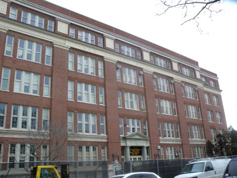
Madison is a residential subsection of Sheepshead Bay, named after the James Madison High School that stands inside it. The school was established in 1925 at 3787 Bedford Avenue, and its alumni include Supreme Court Justice Ruth Bader Ginsburg, class of 1950, and United States Senators Bernie Sanders and Chuck Schumer. The blocks around it are commonly described as running between Kings Highway to the north, Avenue U to the south, Ocean Avenue to the west and Nostrand Avenue to the east — informal lines, not a legal border. Avenue U, one of those informal edges, carries a working commercial strip of restaurants, bakeries and tea shops. The wider Sheepshead Bay area Madison sits within began as part of the Town of Gravesend, and the housing stock that fills Madison today went up after the Shore Parkway section of the Belt Parkway opened in 1941.
-
A 0.051-acre parks triangle where Avenue P, Kings Highway and Ocean Avenue meet.
-
food
A Chinese bakery at 1412 Avenue U, open daily 9 a.m. to 7:30 p.m.
-
food
A branch of Kung Fu Tea at 1422 Avenue U, a chain that dates its first store to Queens in 2010.
-
food
A bakery and cafe at 1505 Avenue U, inspected by the city in July 2026.
-
food
A branch of Vivi Bubble Tea, listed at 1616 Avenue U on the chain's own locations page.
-
food
A restaurant at 1906 Avenue U, inspected by the city in November 2025.
-
food
A small family restaurant at 1915 Avenue U serving Central Asian food, its plov cooked in a kazan.
-
food
An Uzbek restaurant at 1917 Avenue U, halal, with pilaf, kebabs and samsa on the menu.
-
food
An Uzbek restaurant at 1920 Avenue U, listed as serving Uzbek and Russian cuisines.
-
food
A Turkish restaurant at 2007 Avenue U for dine-in and takeout, open daily 11 a.m. to 11 p.m.
-
A Chinese restaurant at 2319 Avenue U, with dishes such as egg foo young on the menu.
Kings Highway along the northern edge
Madison uses ZIP code 11229. The road that runs along its northern edge has colonial roots. Kings Highway traces to a pre-colonial Native trail recorded in a 1652 deed as Mechawanienck, was formalised into a colonial-era highway connecting local roads and cow paths across Kings County, and takes its name from the county — which was itself named for King Charles II in 1683. General Lord Cornwallis marched troops along it on August 26, 1776 on the way to the Battle of Long Island, and George Washington travelled it in 1792 while surveying farmland in Brooklyn, Queens and Suffolk County.
The stretch east of Ocean Avenue — Madison's own northern edge — was widened in 1922 and given landscaped park malls in the manner of Frederick Law Olmsted's parkway designs, though narrower than Olmsted's own Eastern and Ocean Parkways.
The area's resort era belonged to Sheepshead Bay rather than to these blocks: Ocean Avenue opened in 1876, the Long Island Rail Road's Manhattan Beach Branch arrived in 1877 and 1878, and the Sheepshead Bay Race Track ran from 1880 until the 1910 betting ban. That LIRR branch once ran through this part of Brooklyn parallel to today's BMT Brighton Line, near the present Neck Road station, and was discontinued in the mid-1920s. No LIRR service reaches the Madison area today.
The Avenue U storefronts
Avenue U is one of the informal lines different sources use in describing Madison's edges, and it is also a working commercial street. The Avenue U addresses on this page run from 1412 to 2319: Ming Bakery at 1412, Kung Fu Tea at 1422, June's Bakery & Cafe at 1505, Vivi Bubble Tea at 1616, Pho Hoai Restaurant at 1906, Gulchatay at 1915, Sherdor at 1917, Padishah Restaurant at 1920, Little Istanbul at 2007 and No. 1 Chinese Restaurant at 2319.
The same commercial strip carries on into blocks commonly grouped with Homecrest, and where one neighborhood gives way to the other is not fixed by any authority. The sources that describe the two neighborhoods' edges disagree with one another, and none should be treated as definitive.
One site on this page stands away from the avenue: Corporal Wiltshire Square, a small NYC Parks triangle of 0.051 acres, which sits where Avenue P, Kings Highway and Ocean Avenue meet.
Getting there
No subway station is credited to Madison by name. The BMT Brighton Line stations at Kings Highway, Avenue U and Neck Road are each recorded in a neighboring area.
Kings Highway station, at Kings Highway between East 15th and East 16th Streets, sits on the Midwood and Homecrest border; the B stops there on weekdays as an express and the Q at all times, running local. Avenue U station, at Avenue U and East 16th Street, is recorded as serving Homecrest and Sheepshead Bay, with the Q at all times. Neck Road station, at Gravesend Neck Road between East 15th and East 16th Streets, is in Homecrest, with the Q at all times.
The buses recorded as serving the Madison subsection specifically are the B2, B7, B31, B82, B82 Select Bus Service, B100 and BM4 — a different set from the routes listed for the wider Sheepshead Bay neighborhood.
Frequently asked questions
- How do I get to Madison?
- By Q train at all times to Kings Highway, Avenue U or Neck Road on the BMT Brighton Line, or by B on weekdays to Kings Highway. None of those stations is credited to Madison by name — Kings Highway sits on the Midwood and Homecrest border, Avenue U serves Homecrest and Sheepshead Bay, and Neck Road is in Homecrest. The buses recorded for Madison specifically are the B2, B7, B31, B82, B82 SBS, B100 and BM4.
- Why is it called Madison?
- After James Madison High School, established in 1925 at 3787 Bedford Avenue, which sits within the blocks the name covers. Ruth Bader Ginsburg graduated from it in 1950, and Bernie Sanders and Chuck Schumer are also alumni.
- Can I visit James Madison High School?
- It is a large active public high school rather than a museum or a site open to outside visitors, with an enrollment of roughly 3,630 as of 2022-23. It is worth knowing as the source of the neighborhood's name, not as a stop.
- Where does Madison end and Homecrest begin?
- At no settled point. Madison's borders are commonly described as Kings Highway, Avenue U, Ocean Avenue and Nostrand Avenue, and those are informal lines rather than a legal border; the sources describing Homecrest's edges disagree with one another as well. The Avenue U storefronts listed here are the ones this guide carries, and the same commercial strip continues into blocks commonly grouped with Homecrest.
- Is Brennan & Carr in Madison?
- It stands at 3432 Nostrand Avenue, at the corner where Madison's stated boundary meets Sheepshead Bay proper. Wikipedia and the New York Times both file the roast beef restaurant under Sheepshead Bay rather than Madison, and this guide follows them.
- Are there hotels in Madison?
- No. A query of the city's property dataset for ZIP code 11229, which covers these blocks, returned no property carrying a hotel building class. The neighboring guides linked from this page cover the surrounding area.
Connected pages
Shared history
-
Sheepshead Bay, Brooklyn: A Fishing Fleet and a Lost Racetrack
· Sheepshead Bay, New York
Madison is a residential subsection of Sheepshead Bay, named after the James Madison High School that stands within it.
Same region
-
Homecrest, Brooklyn: Homecrest-by-the-Sea and the Avenue U Strip
· Homecrest, New York
The Avenue U commercial strip runs through both, and neither neighborhood's edge along it is fixed by any authority.
-
Midwood, Brooklyn: Vitagraph, Fiske Terrace and Avenue J
· Midwood, New York
The Kings Highway station on Madison's northern edge is on the Midwood and Homecrest border.
What travelers think
Log in to react.
No reviews yet.