
Williamsburg, Brooklyn: Sugar, Shipyards, and a Bridge
Williamsburg, New York
Pictures from Williamsburg
See all 3 photos →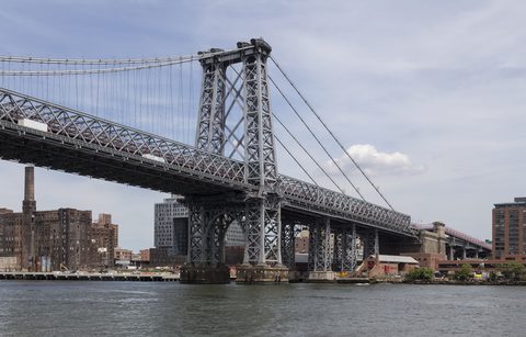
In 1802 the real estate speculator Richard M. Woodhull acquired 13 acres of Brooklyn waterfront and named the settlement Williamsburgh for Colonel Jonathan Williams, the U.S. Army engineer who had surveyed the property. It was incorporated as a village within the Town of Bushwick in 1827, split off as its own Town of Williamsburgh in 1840, and became the independent City of Williamsburgh in 1851 — a city that lasted four years before being annexed into the City of Brooklyn in 1855, the year the final h was dropped from the name. Deep drafts along the East River had already drawn German industrialists to build shipyards here, and sugar refineries, breweries and other manufacturing plants came to dominate the neighborhood through the nineteenth century and into the twentieth.
-
sight
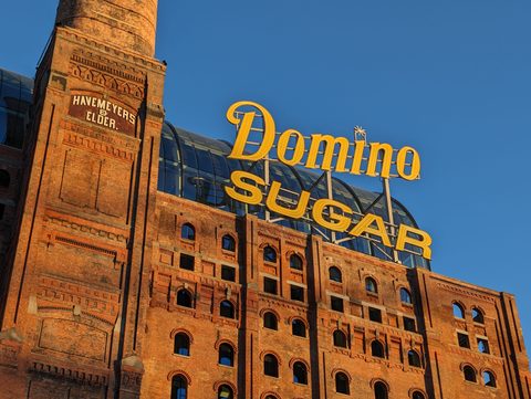
The refinery that ran until 2004, seen from Domino Park. Only the exterior is landmarked; the inside is offices now.
-
walk
Twenty-one salvaged columns from the Raw Sugar Warehouse carry an elevated walkway over six acres of the old refinery grounds.
-
Open year-round on the East River and closing at dusk. Leave the dog and the bicycle behind; both are prohibited.
-
sight
The walkway crosses to Manhattan's Lower East Side. The Brooklyn approach bends to avoid the Williamsburgh Savings Bank Building.
-
sight
A 1936-1938 Public Works Administration complex, landmarked in 2003. It is lived-in NYCHA housing, so this is a walk-past rather than a visit.
-
sight
A community museum of New York ephemera on Metropolitan Avenue, open Thursday through Sunday afternoons.
-
sight
Bowling lanes, a stage and a kitchen inside the old Hecla Iron Works building on Wythe Avenue.
-
food
Brewing in a former matzo factory since 1996. The tasting room runs paid guided tastings; book before turning up.
-
food
The Bamonte family opened Liberty Hall on this block in 1900 and has never let go of it.
-
stay
A 1901 industrial building on Wythe Avenue, converted with its timber ceilings and arched windows intact.
-
stay
Balconies on the rooms and the Westlight bar on the roof, near McCarren Park and the river.
-
food
A Korean BBQ grill in the center of each table at 199 Grand Street, with the kitchen an alternative for the same order.
-
food
Two floors on North 6th Street, opened in June 2026, with the barbecue cooked on grills built into the tables.
Sugar, the bridge, and the Houses
The Domino Sugar Refinery on Kent Avenue is the industry that outlasted all the others. Rebuilt after an 1882 fire, it employed more than 4,500 workers at its 1919 peak and ran continuously until it ceased operations in 2004. Its Pan, Filter, and Finishing House was designated a New York City landmark in 2007 and has since been converted to roughly 460,000 square feet of private office space. The exterior is landmarked and plainly visible from Domino Park, which was built on the refinery grounds and carries 21 preserved columns from the Raw Sugar Warehouse into an elevated walkway.
The Williamsburg Bridge went up between 1896 and 1903 under chief engineer Leffert L. Buck, with Gustav Lindenthal overseeing the final phase, and opened on December 19, 1903 at a cost of $11 million. Its Brooklyn approach was deliberately routed to avoid the Williamsburgh Savings Bank Building, and building it required relocating roughly 10,000 people.
The Williamsburg Houses were the next displacement. Designed by a team led by William Lescaze under chief architect Richmond Shreve, the complex was built between 1936 and 1938 under the Public Works Administration; 568 buildings were demolished and about 5,400 residents relocated to make room. It was designated a New York City landmark on June 24, 2003 and added to the National Register of Historic Places on April 22, 2021. It remains occupied NYCHA housing rather than a visitor site.
In the 1990s the neighborhood became a center of an experimental and DIY arts scene, sometimes called the Brooklyn Immersionists. Galapagos Art Space, founded in 1995 in a former mayonnaise factory on North 6th Street, helped establish that reputation; rising rents drove it to DUMBO in 2007, and it no longer operates in Williamsburg.
The waterfront and the markets
Two of the neighborhood's public spaces sit on the East River. Domino Park occupies six acres of the old refinery site and is open daily from 6am to 11pm, with a playground, a waterfront promenade, sports fields, volleyball and bocce courts, and a dog run. Marsha P. Johnson State Park, near North 7th, 8th, and 9th Streets, opened on May 26, 2007 as East River State Park on the former Brooklyn Eastern District Terminal site; it was renamed in February 2020 and rededicated on August 24, 2020 for the LGBTQ activist Marsha P. Johnson, the first New York state park named for an LGBTQ person. It closes at dusk, and dogs and bicycle riding are prohibited. Inland, McCarren Park straddles the border with Greenpoint.
Smorgasburg, the open-air food-vendor market, runs on Saturdays in Williamsburg and on Sundays in Prospect Park, seasonally from April through October. The market has relocated between nearby lots over its run and no source consulted for this guide pinned down the current site, so confirm the location before setting out.
Getting there
On the L, Bedford Avenue, Lorimer Street and Graham Avenue are all recorded as being in Williamsburg. Grand Street's own locale is given as Williamsburg and East Williamsburg.
On the G, Metropolitan Avenue shares a complex with the L's Lorimer Street, and Broadway sits at the intersection of Broadway and Union Avenue.
On the BMT Jamaica Line elevated, Marcy Avenue is served by the J at all times, the M at all times except late nights, and the Z in the rush-hour peak direction. Hewes Street is served by the J at all times except the weekday peak direction and by the M at all times except late nights; the Z skips it. Lorimer Street on the Jamaica Line carries the J and M. Flushing Avenue, further south, is served by the J and M with the Z skipping it, and its locale is given as Williamsburg, Bedford-Stuyvesant and Bushwick together.
NYC Ferry's East River route calls at two landings named North Williamsburg and South Williamsburg. No source consulted for this guide gave a precise street address or pier location for either, so neither is presented here as sitting in a particular neighborhood.
The Williamsburg Bridge carries a pedestrian and bicycle path to Manhattan's Lower East Side.
Frequently asked questions
- How do I get to Williamsburg?
- By subway, the L calls at Bedford Avenue, Lorimer Street, Graham Avenue and Grand Street; the G calls at Metropolitan Avenue and Broadway; and the J, M and Z serve the Jamaica Line elevated at Marcy Avenue, Hewes Street, Lorimer Street and Flushing Avenue. NYC Ferry's East River route calls at landings named North Williamsburg and South Williamsburg.
- Where does the name Williamsburg come from?
- Richard M. Woodhull named his 1802 waterfront purchase Williamsburgh in honor of Colonel Jonathan Williams, the U.S. Army engineer who surveyed the property. The h was dropped in 1855, when the City of Williamsburgh was annexed into the City of Brooklyn.
- Can I go inside the Domino Sugar Refinery?
- No. The landmarked Pan, Filter, and Finishing House at 292 Kent Avenue has been converted to private office space. The exterior is what is protected, and it is visible from Domino Park next door.
- Why was Marsha P. Johnson State Park renamed?
- It opened on May 26, 2007 as East River State Park. The renaming for the LGBTQ activist Marsha P. Johnson was announced in February 2020 and dedicated on August 24, 2020, making it the first New York state park named for an LGBTQ person.
- Where can I stay in Williamsburg?
- This page lists two hotels: the Wythe Hotel at 80 Wythe Avenue, in a converted 1901 brick industrial building, and The William Vale at 111 N 12th St, which has the rooftop bar Westlight.
- Is the Williamsburg Art & Historical Center open?
- Not at present. The center occupies the landmarked former Kings County Savings Bank at 135 Broadway, which this guide covers under South Williamsburg; its own website reports the building has remained closed to the public since water damage in July 2025.
Connected pages
Nearby
-
South Williamsburg, Brooklyn: The South Side and Los Sures
· South Williamsburg, New York
The 1835 annexation of part of the town of Bushwick produced the district commonly called the South Side of Williamsburgh.
-
East Williamsburg, Brooklyn: Cripplebush and the Third District
· East Williamsburg, New York
The L's Montrose Avenue station is recorded as sitting on the border of East Williamsburg and Williamsburg.
-
Greenpoint, Brooklyn: Where the Monitor Was Built
· Greenpoint, New York
McCarren Park straddles the Williamsburg/Greenpoint border, and NYC Parks describes it as shared by both neighborhoods.
Shared history
-
Bushwick, Brooklyn: Eleven Breweries in Fourteen Blocks
· Bushwick, New York
The Village of Williamsburgh was incorporated within the Town of Bushwick in 1827 and split off as its own town in 1840.
Same region
-
Korean BBQ in Brooklyn: Gowanus, Downtown Brooklyn, Williamsburg and Surf Avenue
· Brooklyn Korean BBQ, New York
Dokebi on Grand Street and Lalaon on North 6th Street are Williamsburg addresses.
See also
-
Lower East Side, Manhattan: Tenements, Reform, and Reinvention
· Lower East Side, New York
The Williamsburg Bridge, opened December 19, 1903, carries a pedestrian and bicycle path across the East River to the Lower East Side.
What travelers think
Log in to react.
No reviews yet.