
Orientation
Stuyvesant Heights, Brooklyn: A 577-Building Historic District Inside Bed-Stuy
Stuyvesant Heights, New York

Stuyvesant Heights supplies the second half of Bedford-Stuyvesant's name, and it sits inside the larger neighborhood rather than beside it: New York City Planning's current Neighborhood Tabulation Area scheme has no polygon called Stuyvesant Heights at all, folding the area into Bedford-Stuyvesant (East), code BK0302, in Brooklyn Community District 3. What sets it apart is a landmark district rather than a city boundary. The area takes its name from Stuyvesant Avenue, its principal thoroughfare, itself named for Peter Stuyvesant, the last Director-General of the Dutch colony of New Netherland; for most of its early history it was outlying farmland belonging to the older settlement of Bedford. The first row of masonry houses went up in 1872 on MacDonough Street for the developer Curtis L. North.
A district, not a boundary
Most of the neighborhood's rowhouses and apartment buildings with ground-floor storefronts were built between about 1870 and 1920, with development accelerating sharply between 1895 and 1900.
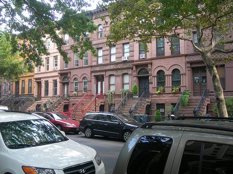
The Stuyvesant Heights Historic District covers 577 contributing residential buildings from roughly 1870 to 1900, mostly two- and three-story high-basement rowhouses in Italianate, Second Empire and Queen Anne Revival styles, on streets including MacDonough, Decatur, Chauncey, Lewis and Stuyvesant. It was listed on the National Register of Historic Places on December 4, 1975, with the listed boundary expanded on November 15, 1996. The New York City Landmarks Preservation Commission designated an Expanded Stuyvesant Heights Historic District on April 16, 2013, extending the locally landmarked area north to Jefferson Avenue, east to Malcolm X Boulevard and west to Tompkins Avenue.
Three churches stand within the district and are named as its landmarks: Our Lady of Victory Catholic Church, Mount Lebanon Baptist Church and St. Phillip's Episcopal Church. Our Lady of Victory's parish was established in 1868, and its church of dark Manhattan schist trimmed in white limestone, at Throop Avenue and MacDonough Street, was built between 1891 and 1895 to designs by the architect Thomas F. Houghton.
Herbert Von King Park lies immediately west. Its eastern edge runs along Tompkins Avenue, the same street the Landmarks Preservation Commission uses as the historic district's western boundary, so sources describe the park as being in Bedford-Stuyvesant generally rather than in Stuyvesant Heights.
Getting there
No subway station is recorded as sitting inside Stuyvesant Heights itself, so the useful stations are the Bedford-Stuyvesant ones on either side of it, and the buses that run along the historic district's boundary streets.
The IND Fulton Street Line runs beneath Fulton Street, the historic district's southern boundary street. Utica Avenue, at Utica Avenue and Fulton Street in Bedford-Stuyvesant, is served by the A at all times, express by day and local late nights, and by the C at all times except late nights. Kingston-Throop Avenues, on Fulton Street between Kingston and Throop Avenues in Bedford-Stuyvesant, and Ralph Avenue, at Ralph Avenue and Fulton Street, are each served by the C at all times except late nights and the A late nights only; the Ralph Avenue source names both Bedford-Stuyvesant and Ocean Hill.
On the elevated BMT Jamaica Line to the north, Halsey Street is served by the J at all times, and Gates Avenue and Chauncey Street each by the J at all times except peak-direction rush hours and the Z during peak-direction rush hours only. Sources place Halsey Street and Gates Avenue at the border of Bedford-Stuyvesant and Bushwick, and Chauncey Street in Bedford-Stuyvesant and Bushwick; none of the three is assigned to Stuyvesant Heights.
Buses reach the district more directly. The B25 runs mainly along Fulton Street, the historic district's southern boundary street, stopping at Tompkins, Lewis and Stuyvesant Avenues. The B46, local and Select Bus Service, runs along Malcolm X Boulevard, the district's eastern boundary street. The B15 runs south from Woodhull Medical Center on Marcus Garvey Boulevard southbound and Lewis Avenue northbound, and Lewis Avenue runs through the district's interior. The B26 reaches Halsey Street by way of Fulton Street, Putnam Avenue and the Nostrand and Bedford Avenue corridor.
What's here
-
Stuyvesant Heights Historic District
577 contributing buildings from roughly 1870 to 1900, best seen on MacDonough, Decatur, Chauncey, Lewis and Stuyvesant.
-
Our Lady of Victory Church
Dark Manhattan schist trimmed in white limestone, built 1891 to 1895 at Throop Avenue and MacDonough Street.
-
Chez Oskar
A French restaurant on Decatur Street, inside the historic district.
-
Akwaaba Mansion
A four-room bed-and-breakfast in an 1860s Italianate villa on MacDonough Street.
Questions
How do I get to Stuyvesant Heights?
The nearest subway stations are Bedford-Stuyvesant's. Utica Avenue on the A and C, and Kingston-Throop Avenues and Ralph Avenue on the C, with the A late nights, all sit on Fulton Street, which forms the historic district's southern edge. Halsey Street on the J, and Gates Avenue and Chauncey Street on the J and Z, sit on the Jamaica Line to the north. The B25 along Fulton Street and the B46 along Malcolm X Boulevard run on the district's own boundary streets.
Is Stuyvesant Heights part of Bedford-Stuyvesant?
It sits inside it. New York City Planning's current Neighborhood Tabulation Area scheme has no polygon named Stuyvesant Heights; the area is folded into Bedford-Stuyvesant (East), code BK0302, in Brooklyn Community District 3. The name survives through the landmark district rather than through any official city boundary.
Where can I stay in Stuyvesant Heights?
Akwaaba Mansion, a four-room bed-and-breakfast in a restored 1860s Italianate villa at 347 MacDonough Street. Its operator describes the property as being in the historic Stuyvesant Heights neighborhood and states that it marked 30 years in business as of 2025.
Connected pages
Shared history
-
Ocean Hill, Brooklyn: A Hill With No Ocean
· Ocean Hill, New York
Ocean Hill was subdivided from the larger Stuyvesant Heights community and established as a distinct area around 1890.
Same region
-
Bedford-Stuyvesant, Brooklyn: Victorian Blocks and Restoration Plaza
· Bedford-Stuyvesant, New York
City Planning's current NTA scheme has no Stuyvesant Heights polygon, folding the area into Bedford-Stuyvesant (East), BK0302.
-
Bushwick, Brooklyn: Eleven Breweries in Fourteen Blocks
· Bushwick, New York
The Jamaica Line stations listed here, Halsey Street, Gates Avenue and Chauncey Street, all sit on the Bedford-Stuyvesant and Bushwick line.