
Brooklyn Heights, Brooklyn: New York's First Historic District
Brooklyn Heights, New York
Pictures from Brooklyn Heights
See all 3 photos →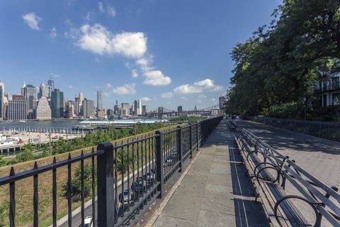
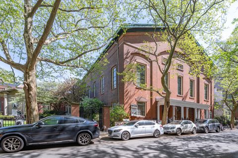
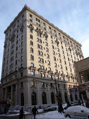
The Lenape knew the bluff above the East River as 'Ihpetonga,' the high sandy bank. The settlement on top of it, originally called Brooklyn Village, grew into a commuter suburb after Robert Fulton's New York and Brooklyn Steam Ferry Boat Company began scheduled steam ferry service in 1814, backed by the landowner Hezekiah Beers Pierrepont, who had accumulated roughly sixty acres and subdivided them. Montague Street filled in as the banking and commercial spine, carrying the Brooklyn Trust Company, People's Trust and National Title Guaranty buildings, and a cluster of hotels went up through the early twentieth century: the St. George in 1885, the Margaret in 1889, the Bossert in 1909, Leverich Towers and the Pierrepont in 1928. When residents organized in the mid-1950s to protect the rowhouse streetscape, the campaign ended in November 1965 with the Landmarks Preservation Commission designating the Brooklyn Heights Historic District, the first historic district ever designated in New York City.
-
The esplanade on the roof of the BQE, running along Columbia Heights between Remsen and Orange Streets.
-
walk
Eighty-five acres of former cargo piers below the bluff, free and open daily from 6 a.m. to 1 a.m.
-
sight
The pedestrian crossing over Furman Street between the Promenade level and Pier 1; the current steel span opened in May 2020.
-
Brooklyn history exhibitions in George B. Post's landmark building of 1878-1881 on Pierrepont Street.
-
sight
Henry Ward Beecher's congregation, with a basement documented as an Underground Railroad passage point.
-
Minard LaFever's church of 1844-1847, a National Historic Landmark and an active co-cathedral.
-
The rowhouse streets designated in November 1965 as New York City's first historic district.
-
A waterfront hotel at Pier 1 of Brooklyn Bridge Park, on the Brooklyn Heights side of Furman Street.
The bluff, the ferry, and the road that never came
Pierrepont's subdivision turned a ferry village into a suburb, and the neighborhood's history since has been written largely on the water below it. The Brooklyn Bridge Park shoreline had been a ferry landing since the mid-1600s and grew into a major nineteenth-century cargo port, with the Empire Stores warehouse complex standing on it.
The defining fight came in 1941, when Robert Moses proposed routing the Brooklyn-Queens Expressway directly through the neighborhood. After the Brooklyn Eagle publicized the plan and residents organized in opposition, engineers agreed instead to a waterfront alignment that carried the highway on two decks against the bluff with a public esplanade cantilevered on top. The southern half of the Brooklyn Heights Promenade opened on October 7, 1950 and the northern half on December 7, 1951; the BQE itself opened to traffic in 1954.
The port's ending produced a second campaign. After the Port Authority ended cargo operations and announced plans in 1984 to sell the piers for private development, Brooklyn Heights and DUMBO residents organized as the Brooklyn Bridge Park Coalition and won public parkland instead. Construction began in 2008, and the park reached substantial completion in 2021.
Getting there
Clark Street, at Clark and Henry Streets in Brooklyn Heights, is served by the 2 at all times and the 3 except late nights.
High Street sits at the threshold of Brooklyn Heights, Dumbo and Downtown Brooklyn, near the Brooklyn Bridge approach, and carries the A at all times and the C except late nights.
Court Street–Borough Hall sits on the Downtown Brooklyn and Brooklyn Heights border, beside Brooklyn Borough Hall. The 2, 3, 4, 5 and R serve it, along with N trains late nights and limited rush-hour W service.
NYC Ferry's nearest landing is Fulton Ferry, adjacent to Brooklyn Bridge Park's Pier 1. It was relocated and renamed from the former DUMBO stop in April 2021, and it is reached from the Heights by way of the Promenade and the Squibb Park Bridge.
The waterfront below the bluff
The Promenade runs along Columbia Heights between the west end of Remsen Street and the west end of Orange Street, cantilevered over the expressway, with the harbor and Lower Manhattan in front of it.
Directly below, the Pier 1 and Pier 2 section of Brooklyn Bridge Park occupies former shipping piers; Pier 1 opened in 2010 and Pier 2 in 2014. The park covers 85 acres in all, is free, and is open daily from 6 a.m. to 1 a.m.
The two levels are joined across Furman Street by the Squibb Park Bridge. The original timber bridge of 2013 was closed repeatedly for structural problems and demolished in 2019; a steel replacement opened to the public on May 4, 2020 and remains open.
Frequently asked questions
- How do I get to Brooklyn Heights?
- Three subway stations sit in the neighborhood or on its edge. Clark Street, at Clark and Henry Streets, is served by the 2 at all times and the 3 except late nights. High Street, near the Brooklyn Bridge approach, carries the A at all times and the C except late nights. Court Street–Borough Hall, beside Brooklyn Borough Hall, is served by the 2, 3, 4, 5 and R, with N trains late nights and limited rush-hour W service. NYC Ferry's Fulton Ferry landing sits beside Brooklyn Bridge Park's Pier 1.
- Was Brooklyn Heights really New York City's first historic district?
- Yes. The New York City Landmarks Preservation Commission designated the Brooklyn Heights Historic District in November 1965, the first historic district ever designated in the city. It was added to the National Register of Historic Places in October 1966 under reference number 66000524, and covers about 140 acres of nineteenth-century rowhouse streets.
- Why is there a public esplanade on the roof of a highway?
- Because the neighborhood refused the alternative. Robert Moses proposed in 1941 to run the Brooklyn-Queens Expressway through Brooklyn Heights itself. Organized opposition, publicized by the Brooklyn Eagle, produced a compromise in which the road was stacked on two decks along the waterfront and the Promenade was cantilevered on top of it. The southern half opened October 7, 1950 and the northern half December 7, 1951.
- Is there a hotel in Brooklyn Heights?
- Yes. 1 Hotel Brooklyn Bridge, at 60 Furman Street on the Brooklyn Heights side of the street, is a currently operating waterfront hotel at Pier 1 of Brooklyn Bridge Park, with East River and Manhattan skyline views.
- What is the Center for Brooklyn History?
- Founded in 1863 as the Long Island Historical Society, later the Brooklyn Historical Society, it merged into the Brooklyn Public Library system in 2020. It occupies a National Historic Landmark building of 1878-1881 by the architect George B. Post at 128 Pierrepont Street, and runs exhibitions and public programs on Brooklyn's history.
Connected pages
Nearby
-
Dumbo, Brooklyn: A Name Coined to Deter Developers
· Dumbo, New York
The High Street station sits at the threshold of Brooklyn Heights, Dumbo and Downtown Brooklyn, near the Brooklyn Bridge approach.
-
Downtown Brooklyn, Brooklyn: Borough Hall and the Fulton Mall
· Downtown Brooklyn, New York
Court Street–Borough Hall stands on the Downtown Brooklyn and Brooklyn Heights border, beside Brooklyn Borough Hall.
-
Cobble Hill, Brooklyn: A Name Revived in 1959
· Cobble Hill, New York
The Pier 6 ferry landing sits on Cobble Hill's border with Brooklyn Heights, where 1 Hotel Brooklyn Bridge stands at 60 Furman Street.
Same region
-
Boerum Hill, Brooklyn: A Name Coined in 1964
· Boerum Hill, New York
The Atlantic Antic street fair spans about ten blocks of Atlantic Avenue across Brooklyn Heights, Cobble Hill and Boerum Hill.
See also
-
Financial District, Manhattan: From Dutch Wall to Wall Street
· Financial District, New York
The A and C at High Street and the 2, 3, 4 and 5 at Court Street–Borough Hall also call at Fulton Street in the Financial District.
What travelers think
Log in to react.
No reviews yet.