_-_south_facade.JPG)
Throgs Neck, the Bronx: Fort Schuyler at the Peninsula's Tip
Throgs Neck, New York
Pictures from Throgs Neck
See all 1 photos →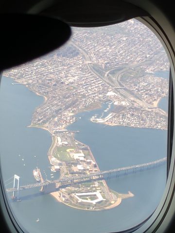
Throgs Neck is a peninsula in the southeastern Bronx, 1.903 square miles (4.93 km²) bounded by the East River and Long Island Sound to the south and east, Westchester Creek on the west, and Baisley Avenue and the Bruckner Expressway on the north. At its tip, where the East River meets the Sound, stands Fort Schuyler, a Third System coastal fortification built between 1833 and 1856 and the campus of SUNY Maritime College since 1938. The Throgs Neck Bridge carries Interstate 295 from the peninsula across to Bay Terrace in Queens. Also on the peninsula are Silver Beach and the Locust Point enclave, Preston High School in the Havemeyer-Huntington mansion, Monsignor Scanlan High School and St. Joseph's School for the Deaf on the Hutchinson River Parkway, and a public library branch on the Cross Bronx Expressway. The ZIP code is 10465; the 2011 population was 21,009.
-
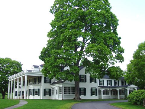
6 Pennyfield Avenue, at the tip of the peninsula. Built 1833–1856, landmarked on April 19, 1966, and home to the Maritime Industry Museum.
-
sight
2780 Schurz Avenue, in the Havemeyer-Huntington mansion. Founded in 1947 by the Sisters of the Divine Compassion.
-
1000 Hutchinson River Parkway. Founded in 1869, on this site since 1876; the brick Romanesque Revival building was completed in 1913.
-
915 Hutchinson River Parkway, on a 13-acre campus. The parish bought land here from St. Joseph's School for the Deaf in 1949; the school was renamed for Monsignor Arthur J. Scanlan in 1972.
-
3025 Cross Bronx Expressway. Operating since 1954 and in its current one-story building since 1974, with a Sesame Street mural in the courtyard.
-
sight
21 Longstreet Avenue, on the outermost block before Eastchester Bay in Locust Point.
Out on the peninsula
Fort Schuyler holds the southeastern tip, where the East River meets Long Island Sound, and SUNY Maritime College's address there is 6 Pennyfield Avenue. Inside the fort are the Stephen B. Luce Library, administrative offices, the Marine Transportation Department and the Maritime Industry Museum, established in 1986. The Havemeyer-Huntington mansion, at 2780 Schurz Avenue, is Preston High School. Monsignor Scanlan High School is at 915 Hutchinson River Parkway and St. Joseph's School for the Deaf at 1000 Hutchinson River Parkway — two addresses on one road, and two halves of what was a single campus until the parkway extension cut it in two in 1939. The New York Public Library's Throg's Neck branch is at 3025 Cross Bronx Expressway; a Sesame Street mural covers the north wall of its courtyard, and the branch is fully accessible, with collections for adults, young adults and children.
The Throgs Neck Bridge crosses from the peninsula to Bay Terrace in Queens, carrying Interstate 295. Othmar Ammann designed it, as he designed the George Washington, Bronx–Whitestone, Verrazzano-Narrows and Triborough bridges. Ground was broken on October 22, 1957 and the bridge opened on January 11, 1961, at a construction cost of $92,000,000. It is a suspension bridge of six lanes, 11,250 feet (3,430 m) long including approaches, with a center span of 1,800 feet (550 m), towers 346 feet (105 m) tall and 142 feet (43 m) of clearance below; each main cable is made of 37 strands of 296 wires, 10,952 wires to a cable. It was built to relieve the Bronx–Whitestone Bridge, two miles west. Twenty thousand vehicles crossed in its first twelve hours, 16.4 million in 1961, its first full year, and daily traffic in 2016 was 119,249. Peregrine falcons have nested on the bridge since at least 1983. Tolls as of January 4, 2026 were $12.03 by mail, $7.46 with a New York E-ZPass and $9.79 at the mid-tier E-ZPass rate.
Locust Point is a related area within Throggs Neck, bounded by Harding Avenue to the north, the Throgs Neck Bridge to the east, and Eastchester Bay: 0.416 square miles, with a population of 1,479 and a median income of $85,072 as of 2011. It was originally Wrights Island, after its owner Captain J. T. Wright, and then Locust Island, until the waterway separating it was filled — the same landfill that carries the Throgs Neck Bridge's northern ramp and toll plaza — turning the former island into a peninsula. The Locust Point Yacht Club occupies the outermost block before the bay, at 21 Longstreet Avenue. Michael Kay is a former resident.
Community District 10 is patrolled by the 45th Precinct of the NYPD, at 2877 Barkley Avenue in Throggs Neck. Two FDNY stations stand in Throggs Neck: Engine Company 89 and Ladder Company 50 at 2924 Bruckner Boulevard, and Engine Company 72 with Satellite 2 at 3929 East Tremont Avenue.
Vriedelandt, Throckmorton and the Battle of Throgs Neck
The New Netherlanders called the peninsula Vriedelandt, "Land of Peace." The current name comes from John Throckmorton, an English immigrant and an associate of Roger Williams, whom the Dutch allowed to settle the area in 1642 with thirty-five others; at the same time the peninsula was also known as Maxson's point. Many of the settlers, Anne Hutchinson among them, were killed in a 1643 uprising, and Throckmorton returned to Rhode Island. By 1668 the peninsula appeared on maps as Frockes Neck, and it was virtually an island at high tide.
In 1776 George Washington's headquarters wrote of a potential British landing at Frogs Neck. It came that October. At the bridge over Westchester Creek, now represented by an unobtrusive steel and concrete span at East Tremont Avenue near Westchester Avenue, General Howe made an unsuccessful effort to cut off Washington's troops; when the British approached, the Americans ripped up the plank bridge and opened a heavy fire that forced Howe to withdraw and change his plans. Six days later Howe landed troops at Rodman's Neck to the north, on the far side of Eastchester Bay.
A farm owned by the Stephenson family was sold in 1795 to Abijah Hammond, who built a mansion that later became the offices of the Silver Beach Garden Corporation. The Morris family purchased land around 1848 and built two mansions on it. The estate that had belonged to Havemeyer and then to Collis P. Huntington carried the Havemeyer-Huntington mansion, which is now home to Preston High School. Silver Beach Garden was formed by the Peters and Sorgenfrel families.
People born or raised in Throggs Neck include Christine Jorgensen, the first transgender celebrity of the 1950s and 1960s, following her surgical transformation in Denmark in 1952, who was born and raised on Dudley Avenue; Doug Marrone, head coach of the Jacksonville Jaguars; Bill Polian, a Hall of Fame executive in the National Football League; and Frank Bello, Charlie Benante, Michael Kay, Sal Mineo, T.J. Rivera and Ritchie Torres.
Getting there
No subway line reaches Throgs Neck. A plan drawn between 1929 and 1939 for a Second Avenue Subway branch to Throggs Neck never materialized. The nearest subway is Westchester Square–East Tremont Avenue, at the intersection of East Tremont and Westchester Avenues, in Westchester Square and on the border of the Pelham Bay neighborhoods; its northbound platform gives a view of the Bronx–Whitestone and Throgs Neck Bridges. Buhre Avenue station, at the intersection of Buhre and Westchester Avenues, is in Pelham Bay.
Buses serve the neighborhood instead. The routes include the Bx8, the Bx40 and Bx42, the Q44 SBS, the Q50 and BxM9 express service. The Bx8 runs between Locust Point, at Longstreet Avenue and Tierney Place, and Williamsbridge, at East 226th Street and White Plains Road, by way of Throgs Neck Boulevard, Crosby Avenue, Williamsbridge Road and Bronxwood Avenue, connecting at its northern end to the 225th Street station on the IRT White Plains Road Line, served by the 2 and 5; some rush hour trips terminate or originate at Westchester Square. The Bx40 and Bx42 connect Morris Heights, at River Park Towers, with SUNY Maritime College and Throgs Neck at Harding Avenue and Emerson Avenue.
No Metro-North station serves Throgs Neck. Penn Station Access's Phase One is adding four Metro-North stations in the Bronx — Co-op City, Morris Park, Parkchester/Van Nest and Hunts Point — and Throgs Neck is not among them.
NYC Ferry's Throggs Neck stop opened on December 28, 2021, when the Soundview route was extended there. The Soundview route itself launched on August 15, 2018, serving East 34th Street in Manhattan, and a Stuyvesant Cove stop was added in May 2020. In July 2025 the New York City Economic Development Corporation announced a plan to merge the Rockaway and Soundview routes, finalized in November 2025.
By road, the Throgs Neck Bridge carries Interstate 295 between the peninsula and Bay Terrace in Queens.
Frequently asked questions
- How do I get to Throgs Neck?
- Not by subway: no line reaches the peninsula. The nearest station is Westchester Square–East Tremont Avenue, at the intersection of East Tremont and Westchester Avenues, in Westchester Square and on the border of the Pelham Bay neighborhoods, with Buhre Avenue, at Buhre and Westchester Avenues, in Pelham Bay. Buses serving the neighborhood include the Bx8, the Bx40 and Bx42, the Q44 SBS, the Q50 and BxM9 express service; the Bx40 and Bx42 run from Morris Heights to SUNY Maritime College and to Harding Avenue and Emerson Avenue, and the Bx8 has its southern terminal at Longstreet Avenue and Tierney Place in Locust Point. NYC Ferry's Throggs Neck stop, on the Soundview route, opened on December 28, 2021. No Metro-North station serves the neighborhood. By road, the Throgs Neck Bridge carries Interstate 295 from Bay Terrace in Queens.
- Why is it called Throgs Neck?
- For John Throckmorton, an English immigrant and an associate of Roger Williams, whom the Dutch allowed to settle the peninsula in 1642 with thirty-five others. Before that the New Netherlanders called it Vriedelandt, "Land of Peace," and it was also known at the time as Maxson's point. By 1668 it was appearing on maps as Frockes Neck, and in 1776 George Washington's headquarters wrote of a potential British landing at Frogs Neck.
- What is Fort Schuyler?
- A coastal fortification at the southeastern tip of Throggs Neck, where the East River meets Long Island Sound, built between 1833 and 1856 as an example of the Third System of American coastal fortifications. At its peak it held 312 guns and could accommodate 1,250 personnel. It was designated a New York City individual landmark on April 19, 1966 and listed on the National Register of Historic Places on June 29, 1976. It has been the campus of SUNY Maritime College since 1938, and houses the college's Stephen B. Luce Library, administrative offices, Marine Transportation Department and the Maritime Industry Museum, established in 1986.
- What happened at the Battle of Throgs Neck?
- In October 1776, at the bridge over Westchester Creek — now represented by an unobtrusive steel and concrete span at East Tremont Avenue near Westchester Avenue — General Howe made an unsuccessful effort to cut off Washington's troops. When the British approached, the Americans ripped up the plank bridge and opened a heavy fire that forced Howe to withdraw and change his plans. Six days later Howe landed troops at Rodman's Neck to the north, on the far side of Eastchester Bay.
- What is the Throgs Neck Bridge?
- A suspension bridge carrying Interstate 295 between Throggs Neck and Bay Terrace in Queens, designed by Othmar Ammann, who also designed the George Washington, Bronx–Whitestone, Verrazzano-Narrows and Triborough bridges. Ground was broken on October 22, 1957 and it opened on January 11, 1961 at a cost of $92,000,000. It runs 11,250 feet (3,430 m) including approaches, with a center span of 1,800 feet (550 m) and 142 feet (43 m) of clearance below, and it was built to relieve the Bronx–Whitestone Bridge, two miles west. Peregrine falcons have nested on it since at least 1983.
Connected pages
Same region
-
City Island, the Bronx: Boatyards, Seafood and One Bridge
· City Island, New York
City Island and Throgs Neck are both part of Bronx Community District 10, along with Country Club, Pelham Bay, Schuylerville and Westchester Square.
-
Pelham Bay Park, the Bronx: 2,772 Acres and Thirteen Miles of Shore
· Pelham Bay Park, New York
Repulsed at Throgs Neck in October 1776, Howe's troops landed six days later at Rodman's Neck, to the north across Eastchester Bay.
-
Steakhouses in Manhattan: Twenty-Three Rooms on the Midtown Spine
· Manhattan Steakhouses, New York
Fiorentina Steakhouse on East Tremont Avenue cuts USDA Prime dry-aged beef and is a Throgs Neck place.
What travelers think
Log in to react.
No reviews yet.