.jpg)
Red Hook, Brooklyn: Basins, Barges, and No Subway
Red Hook, New York
Pictures from Red Hook
See all 3 photos →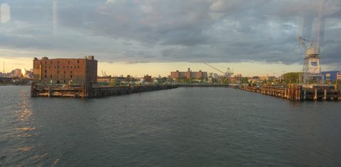
The Lenape called this ground Ihpetonga, meaning a high point of sandy soil. Dutch colonists bought the land in 1636 and named it Roode Hoek for the reddish colour of the soil and the shape of the peninsula, and Red Hook became part of the town of Brooklyn in 1657 by order of Governor Peter Stuyvesant. The nineteenth century turned the peninsula into a working port. Daniel Richards, James S. T. Stranahan and William Beard built the Atlantic Basin, completed in 1850, and the Erie Basin, completed in 1864. Depression-era public works followed in quick succession: the Red Hook Play Center in 1936, the Red Hook Houses in 1939 and the Red Hook Recreational Area in 1940. The neighborhood still has no subway station of its own.
-
Built on the site of former shipping piers, with open water views across Buttermilk Channel to Governors Island and Lower Manhattan.
-
walk
Red Hook's neighborhood green, named for the Cork-born alderman who was instrumental in creating it.
-
Ballfields, a track and an Olympic-size pool, opened in 1940 as the last of the neighborhood's three Depression-era projects.
-
sight
The eleventh and last WPA pool to open in New York City, landmarked in 2008 and still swimming.
-
sight
A museum aboard a 1914 wooden railroad barge, free to visit on most Thursday evenings and Saturday afternoons.
-
sight
Art, music, science and technology under one roof, in a building put up in 1866 for Pioneer Iron Works.
-
sight
Converted from a 1954 freight terminal and opened in 2006 with the arrival of the Queen Mary 2.
-
A working whiskey and rum distillery on Conover Street with scheduled public tours and the Botanica tasting room.
-
food
Serving this waterfront since 1890, flooded by Sandy and back open since September 2013.
-
Italian heroes made for longshoremen since 1922, still run by the Defonte family.
-
food
Texas-style barbecue on Van Brunt Street, closed Mondays.
-
Lobster rolls year-round on Van Brunt Street, with the outdoor Lobster Shack seating shut over winter.
The basins, the barges, and the men who worked them
In 1848 the New York State Legislature funded converting Gowanus Creek into a commercial canal, linking Midwestern grain barges arriving by the Erie Canal to Red Hook's Erie Basin. At its industrial height the 1.5-mile canal saw as many as 26,000 barge passages in a single year.
Erie Basin itself was built from 1851 by William Beard with Jeremiah P. and George Robinson, who had begun buying waterfront land piecemeal from 1843. By the 1920s it was known as The Busiest Place in the Port of New York. It was sold to the Port of New York Authority in the 1950s as trucking and rail reduced demand, and today functions largely as an NYPD vehicle pound.
The dockworkers came in waves: Irish, German and Norwegian first, then Italian and Puerto Rican; African-American longshoremen began working the docks as early as the 1890s, and the Columbia Street area was a recognised Little Italy by the 1920s. In the 1880s a shantytown of roughly 2,000 squatters known as Slab City occupied the land between Hamilton Avenue and the waterfront.
The Depression brought a wave of public investment. The Red Hook Play Center opened in 1936 as the eleventh and last WPA pool to open in New York City; the Red Hook Houses, twenty buildings designed to accommodate 4,462 people, followed in 1939; the Red Hook Recreational Area opened in 1940.
The waterfront now
The late twentieth century was hard on Red Hook. In the 1990s Life magazine named it one of the worst neighborhoods in the United States and called it the crack capital of America. In 1992 Patrick Daly, the principal of P.S. 15, was killed in the crossfire of a drug-related shooting while searching for a student who had left school; the school was later renamed for him.
On June 18, 2008 a 346,000-square-foot IKEA opened at 1 Beard Street. Building it required filling and paving over the historic Red Hook graving dock, a nineteenth-century dry dock, and demolishing Civil War-era waterfront buildings. A city Economic Development Corporation report found that replacing the graving dock would cost roughly a billion dollars, and no replacement has been built.
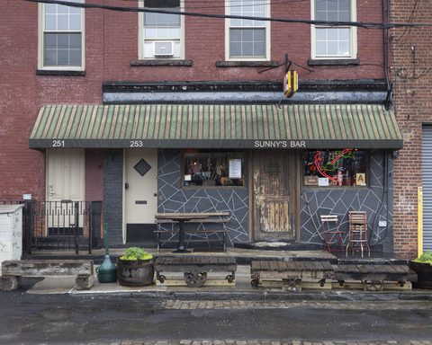
Hurricane Sandy flooded the waterfront in October 2012. Sunny's Bar took extensive flooding and structural damage and stayed shut until September 2013.
The next chapter is already drafted. In September 2025 a community task force voted to approve a $3.5 billion Brooklyn Marine Terminal Vision Plan for the Red Hook waterfront, calling for up to 6,000 apartments, 40 percent of them permanently affordable.
Getting there
Red Hook has no subway station.
NYC Ferry's South Brooklyn route calls at the Red Hook/Atlantic Basin landing, at Ferris Street and Clinton Wharf.
Two bus routes reach the neighborhood. The B61 travels through Red Hook via 9th Street, Van Brunt Street and Columbia Street, continuing along Atlantic Avenue into Downtown Brooklyn at one end and to a Windsor Terrace terminus at 20th Street and Prospect Park West at the other. The B57 terminates in Red Hook at Beard Street and Otsego Street, and runs the other way to 61st Street and Flushing Avenue in Maspeth, Queens.
The nearest subway stations are in other neighborhoods and should be treated as such. Smith-9th Streets, on the F and G, is over the Gowanus Canal near the intersection of Smith and Ninth Streets, in Gowanus. Carroll Street, also on the F and G, is in Carroll Gardens at Carroll and Smith Streets.
Frequently asked questions
- How do I get to Red Hook without a subway?
- By ferry or by bus. NYC Ferry's South Brooklyn route calls at the Red Hook/Atlantic Basin landing at Ferris Street and Clinton Wharf. The B61 runs through the neighborhood via Van Brunt and Columbia Streets, and the B57 terminates at Beard Street and Otsego Street. The nearest subway stations, Smith-9th Streets and Carroll Street, are in Gowanus and Carroll Gardens respectively.
- Where does the name Red Hook come from?
- From the Dutch Roode Hoek, the name colonists gave the land they bought in 1636, for the reddish colour of the soil and the shape of the peninsula jutting into New York Harbor. The Lenape name for the same ground was Ihpetonga, a high point of sandy soil.
- Is there a hotel in Red Hook?
- No hotel is listed here, and lodging should be treated as effectively unavailable inside Red Hook. No hotel from a neighboring neighborhood is named in its place.
- What happened to the Red Hook graving dock?
- It was filled and paved over to build the IKEA store that opened at 1 Beard Street on June 18, 2008, along with the demolition of Civil War-era waterfront buildings. A city Economic Development Corporation report put the cost of replacing the dock at roughly a billion dollars, and no replacement has been built.
- Can visitors go aboard the Waterfront Museum barge?
- Yes. The Waterfront Museum is housed aboard the Lehigh Valley Railroad Barge No. 79 at 290 Conover Street and offers free tours on most Thursdays from 4 to 8pm and Saturdays from 1 to 5pm.
Connected pages
Nearby
-
Columbia Street Waterfront District, Brooklyn: Twenty-Two Blocks by the Bay
· Columbia Street Waterfront District, New York
The district sits on Upper New York Bay between Cobble Hill and Red Hook, and the B61 links the two along Van Brunt and Columbia Streets.
Shared history
-
Gowanus, Brooklyn: A Canal, a Cleanup, a Power Station
· Gowanus, New York
The legislature funded converting Gowanus Creek into a commercial canal in 1848, to link Erie Canal grain barges to Red Hook's Erie Basin.
-
Carroll Gardens, Brooklyn: Front Yards Written Into Law
· Carroll Gardens, New York
Carroll Gardens was originally considered part of South Brooklyn and more specifically Red Hook, until expressway construction hardened the split.
Same region
-
Windsor Terrace, Brooklyn: Forty-Nine Pleasant Cottage Lots
· Windsor Terrace, New York
The B61 runs from Red Hook to a Windsor Terrace terminus at 20th Street and Prospect Park West.
-
Downtown Brooklyn, Brooklyn: Borough Hall and the Fulton Mall
· Downtown Brooklyn, New York
The B61 runs from Red Hook along Atlantic Avenue into Downtown Brooklyn.
What travelers think
Log in to react.
No reviews yet.