
Borgo, Rome: Castel Sant'Angelo, the Leonine City and the Quarter That Was Demolished
Borgo, Rome
Pictures from Borgo
See all 1 photos →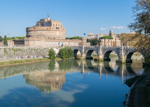
Borgo is Rome's fourteenth rione, the wedge of city between the Tiber and the border of Vatican City. Roma Capitale's Annuario statistico 2022 gives it the toponymic code 114, an area of 0.5 km² and 2,689 residents at the end of 2021; Roma Capitale's own street register, SISTO, records the rione in Municipio I under a council deliberation of 11 March 2013. Italian Wikipedia says Sixtus V constituted it as the fourteenth rione on 9 December 1586, and that its residents are called borghiciani; its main east–west streets are still called borghi rather than vie, and via della Conciliazione is the modern exception. That street is the thing to understand first. What a visitor walks today is not the quarter that stood here in 1935: between 1936 and 1950 the block of houses at the rione's centre was demolished, and a good deal of what this guide describes is what replaced it.
-
sight
Hadrian's mausoleum, later a fortress and a papal refuge, a museum site since 1925 and open Tuesday to Sunday 9.00–19.30, last admission 18.30.
-
About 420 metres of sampietrini between two rows of obelisk lampposts, cut from 1936 across the demolished spina and completed for the Jubilee of 1950.
-
sight
The fortified corridor formed in 1277 under Nicholas III, used as an escape route by Alexander VI in 1494 and Clement VII in 1527.
-
Made a hospital by Innocent III in 1198 on the site of the Schola Saxonum; the Corsia Sistina built for Sixtus IV runs 120 metres by 12 under an octagonal tiburio.
-
sight
Built 1566–1572 under Pius V; only the arcaded courtyard is visitable, Monday to Friday 7.30–18.00 and Saturday 7.30–12.00, and it holds a six-hour clock whose single hand is shaped like a lizard.
-
Opened in 1933 inside the hospital complex, with wax models in the sala Flajani and Paolo Mascagni's anatomical plates; no source states its hours.
-
Built 1538–1590 and consecrated on 17 May 1571, with a bell tower of about 1471–1475 given to Baccio Pontelli.
-
The Carmelite parish church, its dome kept flat and drumless to clear the field of fire of Castel Sant'Angelo's guns; visitor entrance at via della Conciliazione 14.
-
Begun about 1480 for cardinal Domenico Della Rovere; the right wing, holding Pinturicchio's Soffitto dei Semidei of 1490, is visitable on request to the Equestrian Order.
-
Built 1499–1517 for cardinal Adriano Castellesi and faced piazza Scossacavalli until the spina came down; a private residence now, so the façade is what you see.
-
sight
Rebuilt by Antonio da Sangallo il Giovane for Paul III after the Sack of 1527 and left unfinished; the Mura Gianicolensi of 1642 enclosed it and it lost its function.
-
walk
Laid out from 1565 under Pius IV's bull of 5 December, running from via di Porta Castello to via di Porta Angelica.
-
walk
A medieval street in sampietrini along the front of the hospital, known in turn as Burgus Saxonum, Burgus Frisonum, Borgo San Michele and Borgo San Martino.
The spina, and the street that replaced it
Until 1936 a wedge of houses called the spina stood between two streets, Borgo Vecchio and Borgo Nuovo, running from the Tiber towards St Peter's. Borgo Vecchio replaced the collapsed medieval Portica — Italian Wikipedia cites its near-constant width of 6.90 metres as the evidence — and Borgo Nuovo was the Via Alexandrina, opened by Alexander VI for the Jubilee of 1500. Demolition began ceremonially on 29 October 1936 at 09.00, when Mussolini struck the cornice of Palazzo Sauve in piazza Pia with a pickaxe, accompanied by the governor Giuseppe Bottai; the project had been shown to Mussolini at Castel Sant'Angelo on 20 June 1936 and to Pius XI in the Loggia di Raffaello eight days later. Expropriations ran under Regio Decreto 981 of 1931, and the named contractors were Vaselli, La Prenestina, Tudini e Talenti, Federici and Manfredi. By 8 October 1937 the spina had ceased to exist and St Peter's was visible from Castel Sant'Angelo. Most of the displaced residents were moved to the borgate, among them Acilia, and no survey of the old quarter was ever made — only drawings. Piazza Scossacavalli, the square at the centre of the spina, went in 1937; its fountain by Carlo Maderno was re-erected in front of Sant'Andrea della Valle, in rione Sant'Eustachio, where it still stands. So did San Giacomo a Scossacavalli in 1937, the Oratorio di San Filippo Neri in Borgo in 1938, San Michele Arcangelo ai Corridori and the Ospedale di San Carlo in 1939, Santa Maria della Purità between 1937 and 1940, and Sangallo's Palazzo del Governatore di Borgo in 1936–37. None was rebuilt. Older losses lie under the same ground: the Meta Romuli, a pyramidal Roman tomb in the Ager Vaticanus, was demolished in 1499, and the round tomb beside it known as the Terebinto di Nerone had gone from the seventh century. This account is Italian Wikipedia's, citing Vannelli, Parisi Presicce and Petacco, the Archivio Centrale dello Stato, Ceccarelli and Borgatti.
The Vatican edge
Borgo runs up to the border of Vatican City. St Peter's Basilica, St Peter's Square, the Vatican Museums and the Sistine Chapel are inside a sovereign state and belong to no rione. St Peter's Square is Vatican territory under Article 3 of the Lateran Treaty, and the Italian policing carried out there is a concession on foreign soil rather than evidence of Italian territory. Where the line actually runs is not fixed in words: the Treaty fixes it only by an annexed map at 1:5000, with no verbal description at all; the border commission of 1932–33 never had its conclusions ratified; and no source confirms the paving detail commonly described as marking the boundary. Between the two states there is a third legal tier that a visitor walks through without noticing. Under Article 15 of the Treaty, a list of named properties standing on Italian soil — several of them on and around via della Conciliazione — carry the immunities that international law grants to the headquarters of diplomatic agents. They are not Vatican territory and they are not foreign soil; anyone visiting them is subject to Italian law. The Holy See states that its extraterritorial properties in Rome, the Seminario Romano Minore excepted, are named in the Holy See's own enumeration, following the Holy See's 1982 accession to the 1972 World Heritage Convention. The Leonine wall does not mark that border: Leo IV walled the quarter between 848 and 852 after the Saracen sack of 846, with Lothar I decreeing and part-financing the work in October 846, and Paul III and Pius IV extended it to 1565. Most of the surviving circuit is now the Vatican's own perimeter, and only a stretch of it stands in Borgo.
Getting there
Borgo has no metro station inside it. Italian Wikipedia's article on the rione names the Ottaviano station, on metro Line A, as its metro link; the station stands beyond the rione boundary, in Prati. OpenStreetMap's rione and quartiere polygons put Roma San Pietro railway station outside Borgo as well, in Quartiere XIII Aurelio. On the ground the rione has two spines. Via della Conciliazione is the one every visitor uses: about 420 metres of sampietrini between Largo Giovanni XXIII, at the Tiber end, and Piazza Pio XII at the Vatican end, CAP 00193. Under the Janiculum, the Galleria Principe Amedeo di Savoia-Aosta carries road traffic through a single bore of 0.250 km to its portal at Porta Santo Spirito; motorcycles under 125 cc are excluded from it. To steer by, Roma Capitale gives Castel Sant'Angelo's address as Lungotevere Castello 50, and the parish of Santa Maria in Traspontina gives its own visitor entrance as via della Conciliazione 14. This guide publishes no walking times and no distance it has not taken from a source, so work the geography out from the street numbers rather than from an impression.
Frequently asked questions
- How do I get to Borgo?
- Borgo has no metro station inside it. Italian Wikipedia's article on the rione names Ottaviano, on metro Line A, as the rione's metro link; that station stands beyond the rione boundary, in Prati. OpenStreetMap's rione and quartiere polygons put Roma San Pietro railway station outside Borgo as well, in Quartiere XIII Aurelio. Inside the rione the main axis is via della Conciliazione, about 420 metres of sampietrini running between Largo Giovanni XXIII at the Tiber end and Piazza Pio XII at the Vatican end, CAP 00193; under the Janiculum the Galleria Principe Amedeo di Savoia-Aosta brings road traffic to its portal at Porta Santo Spirito, and motorcycles under 125 cc are excluded from it. This guide publishes no walking times, so steer by street numbers: Roma Capitale gives Castel Sant'Angelo's address as Lungotevere Castello 50, and the parish of Santa Maria in Traspontina gives its visitor entrance as via della Conciliazione 14.
- Is St Peter's Basilica in Borgo?
- No. St Peter's Basilica, St Peter's Square, the Vatican Museums and the Sistine Chapel are inside Vatican City, a sovereign state that belongs to no rione. St Peter's Square is Vatican territory under Article 3 of the Lateran Treaty; the Italian policing there is a concession on foreign soil, not evidence of Italian territory.
- Where exactly does Vatican City begin at the end of via della Conciliazione?
- No source states it precisely, and the reason is in the Lateran Treaty itself: the Treaty fixes the border only by an annexed map at 1:5000, with no verbal description, and the border commission of 1932–33 never had its conclusions ratified. No source confirms the strip of paving often described as marking the line.
- What does it mean that some buildings in Borgo are called extraterritorial?
- It is a third legal tier, and it is not the Vatican. Under the Lateran Treaty of 11 February 1929, Italy recognises the Holy See's full ownership of this property (Art. 13; Annex II). Art. 15 states that the property, «benché facenti parte del territorio dello Stato italiano» — although forming part of the territory of the Italian State — enjoys the immunities that international law grants to the headquarters of the diplomatic agents of foreign States. It is on Italian soil and visitors are subject to Italian law. In Borgo the Holy See's own published enumeration names the Palazzo del Sant'Offizio and its adjacencies, the Palazzo dei Convertendi, the Palazzo delle Congregazioni ai Propilei and the Palazzo Pio, and on the Janiculum the church of Santi Michele e Magno, the Collegio Internazionale S. Monica, the Jesuit Curia Generalizia and the buildings adjoining it on Borgo Santo Spirito.
- When is Castel Sant'Angelo open?
- Roma Capitale states the museum opens Tuesday to Sunday 9.00–19.30, last admission 18.30, closed Mondays, 25 December and 1 January. From 3 August 2026 and for the rest of 2026 it also opens on the first Monday of each month, 14.00–20.00, last admission 19.00, with a 5-euro ticket, no booking and no groups.
- What happened to the streets in the middle of Borgo?
- They were demolished. Between 1936 and 1950 the spina — the wedge of houses between Borgo Vecchio and Borgo Nuovo — was cleared to open via della Conciliazione. Italian Wikipedia records that by 8 October 1937 the spina had ceased to exist and St Peter's was visible from Castel Sant'Angelo, that most of the displaced residents were moved to the borgate, and that no survey of the old quarter was ever made, only drawings.
- Which churches and museums in Borgo have published hours?
- Santa Maria in Traspontina does: its own site lists weekday Eucharistic celebration as 9.00 - 19.00, Sunday and feast-day celebrations at 9.00, 10.30, a 12.30 international Mass and 19.00, and the Rosary daily at 18.15. Roma Capitale gives the Palazzo del Commendatore's courtyard as visitable Monday to Friday 7.30–18.00 and Saturday 7.30–12.00, during the hospital's hours. Santo Spirito in Sassia and the Museo storico nazionale dell'arte sanitaria have no hours here: no source states them, so none are given.
Connected pages
Nearby
-
Trastevere (R. XIII), Rome: Fountains, the Janiculum and 1849
· Trastevere, Rome
The Bambino Gesù hospital and Sant'Onofrio al Gianicolo are on the Holy See's extraterritorial list, but they stand in Trastevere, not Borgo.
-
Vatican City: St Peter's, the Vatican Museums and the Sistine Chapel
· Vatican City
The rione that runs up to the border of Vatican City, holding via della Conciliazione, piazza Pio XII and the Holy See palaces that stand on Italian soil.
-
Ponte, Rome: the bridge the rione is named for, Palazzo Altemps and via dei Coronari
· Ponte, Rome
Ponte Sant'Angelo and Ponte Vittorio Emanuele II each lie in Ponte and in Borgo, where Ponte Sant'Angelo meets Castel Sant'Angelo.
Shared history
-
Monti, Rome: The North Half of the Imperial Fora, Four Towers and the Lateran
· Monti, Rome
Santa Maria Maggiore, in Monti, is a Lateran Treaty extraterritorial property of the same third tier as Borgo's Holy See palaces.
Same region
-
Campitelli, Rome: the Capitoline, the Roman Forum and the Palatine
· Campitelli, Rome
Campitelli, across the Tiber, holds the Roman Forum, the Palatine and the Capitoline Museums.
-
Monti, Rome: The North Half of the Imperial Fora, Four Towers and the Lateran
· Monti, Rome
Borgo is rione XIV in Roma Capitale's toponymic list of Rome's 22 rioni; Monti is rione I.
See also
-
3 Days in Rome: Colosseum Arena Floor, the Vatican, and the Back Streets of Monti
· Rome, Italy
A three-day Rome itinerary that takes in the Vatican and lunch in Borgo's side streets.
What travelers think
Log in to react.
No reviews yet.