.jpg)
Havering, London: Romford Market, Upminster Windmill, Rainham Hall, Hornchurch Country Park and Havering-atte-Bower
Havering, England
Pictures from Havering
See all 1 photos →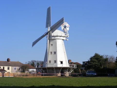
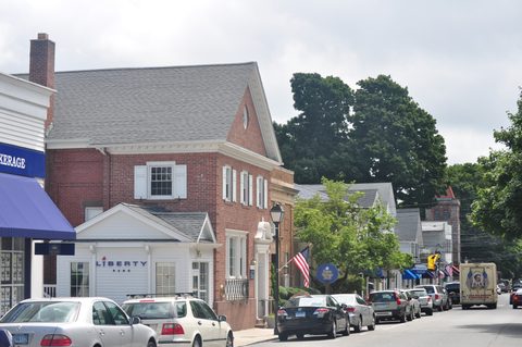
Havering is an outer London borough on the eastern edge of the capital, and it reads as four settlements rather than one. Romford holds a market chartered in 1247 that still trades three days a week, a spired parish church of 1849-50 at the head of the market place, and the borough museum on the High Street; three miles north the ground climbs to two country parks and a village green with stocks on it. Hornchurch keeps a Grade I church, a Georgian house in Humphry Repton grounds and a producing theatre, with 257 acres of country park laid over the runways of RAF Hornchurch. Upminster has a smock mill of 1803 turning again and a thatched grange barn of 1450. Rainham runs down to the Thames marshes. The National Heritage List for England records 146 listed buildings inside the borough: 6 Grade I, 15 Grade II* and 125 Grade II.
-
sight
A market the council dates to 1247, trading on Market Place Wednesday and Friday 9am to 4.30pm and Saturday 9am to 5pm, with pitches from £20 a day.
-
John Johnson's church of 1849-50 at the head of Market Place, its spire 162 feet high, listed Grade II* as NHLE 1358535.
-
sight
The borough museum at 19-21 High Street, open Wednesday to Friday 11am to 4.30pm; adults £3.00 and children up to 16 free.
-
walk
215 acres with a captive red deer herd, an Essex Wildlife Trust visitor centre and Green Flag status since 2007; free, with a car park off Broxhill Road.
-
165 acres of the estate of the medieval Royal Palace of Havering, with an avenue of 100 Wellingtonia planted by the McIntosh family after 1828.
-
Stocks and a whipping post on the green at Orange Tree Hill, listed Grade II as NHLE 1079930, with the Grade I Bower House of 1729 about 400 m south.
-
Listed Grade I as NHLE 1358529, on a site held by Hornchurch Priory from 1163, with a bull emblem on the wall since about 1600.
-
A Georgian mansion listed Grade II as NHLE 1358503 in grounds remodelled by Humphry Repton; gardens open 8am to dusk, given to the town on 1 June 1929.
-
A producing theatre built by the council in 1974 and opened by Sir Peter Hall in April 1975, listed Grade II as NHLE 1480655. Box office 01708 443333.
-
257 acres over the runways of RAF Hornchurch, with pill boxes, Tett turrets and the Ingrebourne Marshes Site of Special Scientific Interest alongside.
-
Volunteer-run galleries on Suttons Lane covering 1915 to the present; Saturday and Sunday 11am to 4pm, adults £6.00 and children £3.00 on the door.
-
tour
A smock mill of 1803 restored to working order 2016-2023, listed Grade II* as NHLE 1079878; six open days published for 2026, from 12 September.
-
A thatched grange barn of 1450, a scheduled monument as NHLE 1001991. The museum inside is closed and its 2026 open days are to be confirmed.
-
Listed Grade I as NHLE 1184679, its thirteenth-century tower used by rector William Derham for the first accurate measurement of the speed of sound.
-
Listed Grade II as NHLE 1079925, rebuilt in 1873, with James Oglethorpe, founder of Georgia, buried beneath the chancel.
-
tour
Captain John Harle's merchant house of 1729, listed Grade II* as NHLE 1358506, open Wednesday to Sunday with a garden, café and second-hand bookshop.
-
Listed Grade I as NHLE 1358505 and standing about 45 m north of Rainham Hall, with Rainham's Grade II clocktower war memorial, NHLE 1063900, nearby.
-
A twelfth-century church listed Grade II* as NHLE 1079886, which came through the wildfire of 19 July 2022 in a village of about 300 people.
Romford and Havering-atte-Bower
Romford is the borough's commercial centre and the market is the reason it exists. Three miles north the ground rises to a wooded ridge carrying two country parks and a village green.
Romford Market trades on Market Place, RM1 3ER, on Wednesday and Friday from 9am to 4.30pm and on Saturday from 9am to 5pm. The council states that the market was 'first opened in 1247 by Royal Order during King Henry III's reign', originally selling sheep and cattle, and that it 'soon become a key trading centre and was well established as a supplier of goods to London'. Access is from St Edwards Way, Market Link, Laurie Walk, Swan Walk, High Street, South Street, North Street and Mercury Gardens; pitch rent for casual traders starts at £20 a day, and the stalls run to fruit and vegetables, a fishmonger, a butcher, street food, clothing, homeware and plants. Public toilets open on market days on the ground floor of Tollgate House, with disabled cubicles and baby changing. The market place lies inside the Romford conservation area, one of eleven conservation areas of the London Borough of Havering; conservation areas are borough-designated and carry no list entry number.
The Church of St Edward the Confessor stands at the head of Market Place, RM1 3AB, and was listed Grade II* on 4 July 1952 as NHLE 1358535, under the statutory name 'Parish Church of St Edward the Confessor'. The present building went up in 1849-50 to designs by John Johnson, replacing a church completed in 1410 and demolished in 1849, and its spire is 162 feet high. The chancel holds a monument to George Hervey and a memorial to Anthony Cooke attributed to the sculptor Cornelius Cure; the glass includes an east window by Charles Edmund Clutterbuck and three south chapel windows by William Wailes. Romford War Memorial nearby carries its own Grade II listing, NHLE 1452855, made on 9 January 2018. It is a working parish church and no source states its opening hours, so none are given here.
Havering Museum occupies 19-21 High Street, RM1 1JU, and opens Wednesday to Friday from 11am to 4.30pm, with last entry to the galleries at 3.30pm and to the shop at 4pm. Adult admission is £3.00 and children up to 16 go free, supervised at all times; an annual season ticket is £15.00 for adults and £12.00 for senior citizens, and guided tours for groups of ten or more are £2.00 a head, bookable on 01708 766 571. The museum collects and preserves objects which record the history of the London Borough of Havering, and it warns that it sometimes has to close at short notice if volunteers become unavailable, so check the news flash on its front page before travelling. It is a charity, number 1093763.
Bedfords Park, entered from Broxhill Road, Havering-atte-Bower, RM4 1QL, is 215 acres of council parkland between Collier Row and Harold Hill. There are no restrictions on access, and the car park closes at about dusk and opens by 8am. The park is a Local Nature Reserve, has held Green Flag status since 2007 and keeps a herd of captive red deer; an Essex Wildlife Trust visitor centre was built in 2003 on the site of the old mansion house and cafeteria. The council took ten years of Natural England Higher Level Stewardship funding in 2013 and Red Poll cattle were first used to graze the park in spring 2014. Ancient woodland indicator species in the park include remote sedge, bluebell, wild service tree and wood melick. The name is thought to derive from a John Bedford or Bedforde who held land in the area in 1362; Bedfords was taken into the Gidea Hall estate in 1412 and sold as a separate estate in 1659. Upper Bedfords Farmhouse, built by John Heaton as the estate's home farm, is listed Grade II, NHLE 1079901.
Havering Country Park is 165 acres, entered from Wellingtonia Avenue, RM4 1QP, and from Clockhouse Lane, RM5 2RR, with no restrictions on access and no car park and no toilets on site. Its avenue of Wellingtonia, or giant sequoia, was planted by the McIntosh family, who bought the manor from the Crown in 1828, built an Italianate house on the site of the old palace and laid out a park of some 250 acres; the council counts 100 trees. The land was part of the estate of the medieval Royal Palace of Havering. William the Conqueror kept the manor of Havering for himself in 1066, and the council writes that 'Henry II's and Henry III's records frequently refer to building repairs and upkeep of the park, including the construction of a bath for the king in 1215'. A survey of the King's property in 1650 described the palace as 'a confused heap of ruinous decayed buildings whose materials of lead, glass, brick, tile, timber and stone [were] valued at £480', and by 1816 there was no trace of where it had stood. After Charlotte McIntosh's death the mansion was demolished in 1925 and the estate sold in one-acre plots at about £30 each — the Plotlands along Wellingtonia Avenue and Pinewood Road, popular from the 1920s to the 1940s, of which two bungalows survive, one as the park office. A compulsory purchase order cleared the Plotlands from 1970, the country park opened in 1976 and Havering Council acquired it from the Greater London Council in 1986. A cache of Roman coins found in the park suggests a Roman villa, and the council notes that the straight line of Clockhouse Lane may follow a Roman road. The park adjoins the Havering-atte-Bower conservation area to the west and does not lie within it.
The village green at Havering-atte-Bower is on Orange Tree Hill, RM4 1PJ, and the stocks and whipping post standing on it were listed Grade II on 4 July 1952 as NHLE 1079930; Havering Council names them among the borough's historic buildings as 'Stocks, Havering-atte-Bower'. Facing the green, the Church of St John the Evangelist was built in 1878 to replace an older chapel of St Mary and is listed Grade II, NHLE 1183663, first listed on 4 July 1952 and amended on 14 September 1979. About 400 m south on Orange Tree Hill, the Bower House was built in 1729 by John Baynes using materials from the demolished Havering Palace and is listed Grade I, NHLE 1079873, with its stable block separately Grade I, NHLE 1079874; the Round House on the same ridge is Grade II*, NHLE 1183562. The Royal Liberty of Havering, a self-governing jurisdiction covering the parishes of Havering-atte-Bower, Hornchurch and Romford, ran from 1465 to 1892. Havering Palace was used by royalty into the seventeenth century, and the surviving plan of it comes from a survey ordered by Lord Burghley in 1578. The village is the Havering-atte-Bower conservation area.
Hornchurch and the Ingrebourne valley
Hornchurch is a High Street with a Grade I church on it, a Georgian house and a producing theatre facing each other on Billet Lane, and a country park on the Ingrebourne laid over an airfield.
The Church of St Andrew, High Street, RM11 3UU, was listed Grade I on 7 January 1955 as NHLE 1358529, under the statutory name 'Parish Church of St Andrew'. A church has stood on the site since at least 1163, when Henry II granted it to Hornchurch Priory, and the tower and north porch were added in the fifteenth century. The place name Hornchurch means 'church with horn-like gables'; the bull emblem on the wall has been there since about 1600, and both it and the bull's-head seal used by the priory on fourteenth-century documents derive from the name rather than providing its origin. The interior holds memorials to the daughters of William Blackborne and to Levett Blackborne, a Lincoln's Inn barrister, and a monument to Thomas Clutterbuck, treasurer of the Navy, who died in 1742. The churchyard contains 37 Commonwealth war graves from the First World War and four from the Second. The church stands inside the St Andrews conservation area, and Hornchurch War Memorial nearby is listed Grade II, NHLE 1480701, on 22 April 2022. No source states the church's opening hours, so none are given here.
Langtons stands on Billet Lane, RM11 1AX, and was listed Grade II on 19 January 1978 as NHLE 1358503. Three further Grade II entries in the same grounds were listed on the same day: the Orangery, NHLE 1079918; the Gazebo and Bath House, NHLE 1358504; and the Stable Block, NHLE 1079919. The council calls the house 'a Georgian red brick mansion which acts as our registry office' and the grounds 'a historic garden with a serpentine lake and path network'; the remodelling of the grounds is attributed to Humphry Repton, who incorporated paths, walls, lake, gardeners' bothies, a 'mazy' shrubbery, an enclosed orchard and fine timber trees. The site now covers about 11 acres, against roughly 90 acres of parkland, paddocks and orchards originally. The land was recorded as 'Langedun' in the thirteenth century and a building called Marchauntes — a medieval word for merchants — stood here in 1446; the two-storey wings, the orangery and the stable block were added in the mid to late eighteenth century, and the bath house is an early nineteenth-century feature. On 1 June 1929 Langtons was given to the town of Hornchurch by Varco Williams and his daughter Elizabeth Parkes, with the proviso that the house should be maintained and the gardens kept open to the public. The gardens open between 8am and dusk and are not locked; there is a tea shop in the courtyard with toilets, open when the tea shop is open, and pay and display parking on Keswick Avenue and Theatre Road. The grounds are the Langtons conservation area.
The Queen's Theatre stands opposite Langtons Gardens on Billet Lane, RM11 1QT, and was listed Grade II on 13 May 2022 as NHLE 1480655, under the statutory name 'Queens Theatre'. Havering Theatre Trust Ltd was established in 1953 and the company opened in a converted cinema in Station Lane with a production of See How They Run; the London Borough of Havering built the present theatre in 1974, and Sir Peter Hall opened it in April 1975 with Joseph and the Amazing Technicolour Dreamcoat. It describes itself as the producing theatre serving outer east London and south Essex, with a catchment of more than a million people and over 220,000 people a year at its programme. Sets and costumes are made on site by a carpentry workshop, scenic artists, prop makers and a wardrobe team. The theatre took UK Theatre's Most Welcoming Theatre award in 2016, 2017 and 2018, was named London Theatre of the Year in The Stage Awards 2020, and has completed QNew, a £1.3 million capital project. Charity number 248680; the box office is on 01708 443333.
Hornchurch Country Park, entered from Squadrons Approach, RM12 6TS, is about 257 acres created from a landfill site in 1980 over the First World War airfield at RFC Suttons Farm and the Second World War RAF Hornchurch. Pedestrian access is unrestricted; the car parks close at about dusk and open by 8am. RFC Suttons Farm opened on 3 October 1915, and on the night of 2/3 September 1916 Lieutenant William Leefe Robinson took off from it and shot down the airship SL11, which crashed in flames near Cuffley; he was awarded the Victoria Cross. Suttons Farm closed on 31 December 1919, the site was bought back from New College Oxford, RAF Suttons Farm opened in 1928 and was renamed RAF Hornchurch a few months later to make it easier to find on public transport, and the airfield closed in April 1962. The council states that the main car park at Squadrons Approach 'was an aircraft dispersal bay used to protect Spitfires and their ground crews during the war', and the park holds well-preserved pill boxes and Tett turrets. Ingrebourne Marshes, running down the eastern side, are a Site of Special Scientific Interest carrying a freshwater reed bed; public access to the marshes is restricted but they are visible from within and outside the park, and spotted crake and bittern have been recorded in recent years. The Essex Wildlife Trust opened its Ingrebourne Valley Visitor Centre in the park in 2015, with food and refreshments. Albyns Farmhouse at the south-western edge is listed Grade II, NHLE 1299961. The RAF Hornchurch conservation area is a separate site of 0.93 hectares (2.31 acres) at Astra Close and 89-99 Wood Lane, South Hornchurch, designated on 7 June 1989, and the country park is not within it.
The RAF Hornchurch Heritage Centre sits at 119-121 Suttons Lane, RM12 6RU, on the former airfield at the park's northern edge. It opens Saturday and Sunday from 11am to 4pm and takes group and school bookings Monday to Friday. Admission without the voluntary donation is £6.00 for an adult aged 16 and over, £3.00 for a child aged 5 to 15 and £15.00 for a family of two adults and three children; with the 10% Gift Aid donation those become £6.60, £3.30 and £16.50, under-fives go free and one personal assistant per disabled visitor goes free. Tickets are sold on the door and advance booking is not required. The Hornchurch Aerodrome Historical Trust runs it, charity number 1182040, staffed by volunteers, with a tea room and a car park, and it holds a National Lottery Heritage Fund grant towards its educational and outreach work. Its galleries run as Suttons Farm 1915-1919, Inter-War Years 1920-1938, The War Years 1939-1945, Post War Years 1946-1962 and Life After the Airfield 1962-Present, with sections on the WAAFs, the nationalities who served, signalling and aircraft.
The designated fabric of this part of the borough reaches into the late twentieth century: the Rom Skatepark on Upper Rainham Road, RM12 4ES, was listed Grade II on 11 September 2014 as NHLE 1419328. It was built in 1978 to a design by Adrian Rolt of G-Force and covers 8,000 square metres (86,000 square feet), with a central 4,000 square metres surfaced in shotcrete.
Upminster and Cranham
The rural east of the borough: a working smock mill and a Grade I church tower within 600 m of Upminster station, a thatched grange barn of 1450 on Hall Lane, and a village church at Cranham with the founder of Georgia under the chancel floor.
Upminster Windmill stands on St Mary's Lane at Highview Gardens, RM14 2QL, and was listed Grade II* on 7 January 1955 as NHLE 1079878. It is an English smock mill built in 1803 for James Nokes of Hunt's Farm in Corbets Tey Road: four storeys of smock on a single-storey brick base, 52 feet (15.85 m) to the top of the cap, with the cap thought to be the work of the millwright William Bear of Ballingdon. Four double patent sails span 70 feet, with twelve bays of three shutters per sail and 288 shutters in total, each carved with a Roman numeral; the compass-arm great spur wheel is 10 feet in diameter with 126 cogs. There are four pairs of millstones — three pairs of French Burr and one pair of Peak, two pairs 4 ft 6 in in diameter and two 4 ft — and a steam engine added in early 1811 drove two pairs of them. Commercial working stopped in 1934. The mill was restored to working order between 2016 and 2023 and reopened to visitors in 2023, with a new visitor centre alongside; the London Borough of Havering and the Friends of Upminster Windmill work in partnership to protect it, and the project drew support from the Heritage Lottery Fund, Veolia North Thames Trust and the Architectural Heritage Fund. The Friends have published six open days for 2026: 12 September 10am to 4pm, 13 September 11am to 4pm, 27 September 11am to 4pm, 10 October 10am to 4pm, 11 October 11am to 4pm and 25 October 11am to 4pm. About 160 m due south, the Second World War Upminster Report Centre, including a gas cleansing station and other civil defence buildings, is listed Grade II, NHLE 1484138, on 15 August 2023.
Upminster Tithe Barn, on Hall Lane, RM14 1AU, is a scheduled monument, NHLE 1001991, scheduled on 5 November 1971 under the name 'Medieval grange barn, 228m south-east of Upminster Court', over 0.0507 hectares; a scheduled monument carries no grade, and the barn is not separately listed. The Museum of Nostalgia inside it is closed. Its open days page carries the 2025 closure notice — the barn shut for the season while a programme of works was undertaken on its structure and roof, funded by a grant from National Highways — and gives its 2026 open days as to be confirmed, 10.30am to 4pm. The museum states that 'The Barn dates from 1450 and was part of an estate that supported the Abbey of Waltham. The Abbott's hunting lodge next door was later converted to a private house and is now home to Upminster Golf Club.' That lodge is Upminster Hall, Grade II*, NHLE 1079889. The box frame is English oak: 20 main aisle or arcade posts, 20 wall posts and 6 end-frame posts, with ten 20-foot tie beams spanning the nave and twenty 10-foot aisle tie beams, jointed with tenons and wooden trenails. The roof is thatched — re-thatched in natural Norfolk reed in 1965, burnt in the centre by fire in 1973 and repaired in 1975 — and both gable ends are half-hipped; brown long-eared bats and pipistrelles live in the thatch. The barn was refurbished and opened as an agricultural museum in 1976 and holds domestic items from the last century alongside agricultural machinery. Entry is free with a donation welcomed when it opens, and there is a free public car park adjacent with disabled parking.
The Church of St Laurence, St Mary's Lane, RM14 2QB, was listed Grade I on 7 January 1955 as NHLE 1184679. The tower is thirteenth-century, with rubble walls, buttresses at its base and a leaded, shingled spire of the Essex type. The church was renovated in 1862-63 under W. Gibbs Bartleet and substantially rebuilt in 1928 by Sir Charles Nicholson, who restructured the interior and added new chapels. William Derham, rector of Upminster, used the tower to make the first accurate measurement of the speed of sound; he is buried in the church and, at his own wish, no memorial marks the grave. There are monuments to the Branfills of Upminster Hall and the Esdailes of Gaynes, and six Second World War service personnel are commemorated in the churchyard. Upminster War Memorial, about 60 m east, is listed Grade II, NHLE 1433648, on 18 April 2016. No source states the church's opening hours, so none are given here.
The Church of All Saints, The Chase, Cranham, RM14 3YB, was listed Grade II on 14 September 1979 as NHLE 1079925, and the church was rebuilt in 1873. James Oglethorpe, founder of the colony and state of Georgia, is buried with his wife at the centre of the chancel, and a railed tomb west of the church carries its own Grade II listing, NHLE 1358509. Cranham Hall, the former manor house, stands about 45 m south and is listed Grade II, NHLE 1358508, with its garden walls separately Grade II, NHLE 1183600. Cranham is one of the eleven conservation areas of the London Borough of Havering, designated in 1968, and one of three — with Gidea Park and Havering-atte-Bower — carrying an Article 4 Direction; in Cranham that direction means planning permission is required for gates, walls, fences or other means of enclosure. There is no bus stop within 500 m of the church; the 248 and the 346, about a mile west on St Mary's Lane and Front Lane, are the nearest routes, so Cranham is a walk. No source states the church's opening hours, so none are given here.
Rainham and the Thames-side south
The low ground below the A13 at the eastern edge of London: a Grade I Norman parish church and a merchant's house of 1729 about 45 m apart in one village centre, and Wennington and the marshes running out to the Thames.
Rainham Hall stands on The Broadway, RM13 9YN, and was listed Grade II on 7 January 1955 as NHLE 1358506. Captain John Harle, a shipping merchant, built it in 1729. The National Trust runs it and holds one property in the London Borough of Havering. The house opens Wednesday to Sunday and closes Monday and Tuesday; the Trust's calendar for September to December 2026 marks every Monday and Tuesday closed, and the times published for 4 September 2026 were 11am to 4pm for the Hall, 11am to 4.30pm for the garden and 11am to 4pm for the café. The Hall reopened after a £2.5 million conservation project supported by the Heritage Lottery Fund, Veolia North Thames Trust and Biffa Award. Changing exhibitions cover four periods of its history — the 1700s, the Victorian era, post-war and the 1960s — over three floors, with a Tag Trail Challenge for children; the restored stable block and coach house set out the history of the house, and there is a second-hand bookshop, a café, a natural play area with a mud kitchen and bug hotels, and a community garden of formal and informal areas, woodland, lawn, orchard and vegetable plots. The Hall was used as a film location for a UK film of Sense and Sensibility in August 2025, and an exhibition about the filming runs from 26 September to 19 December 2026. The Trust states that the Hall is not wheelchair accessible: there are accessible toilets in the stable block, a lift in the stable block only, and step-free access to the garden from Wennington Road or The Broadway, and the Coach House holds a 360 virtual tour, a subtitled film, an image book, a sensory tool bag and large print and braille guides. Four further entries stand in the curtilage — the Stable Block, Grade II, NHLE 1183554; The Lodge, Grade II, NHLE 1079923; the Forecourt Railings, Gates and Piers Walls and Vases, Grade II, NHLE 1079922; and the Wall and Gate Piers between numbers 15 and 37, Grade II, NHLE 1184858 — so read what each entry names before attaching a grade to the house.
The Church of St Helen and St Giles stands about 45 m north of the Hall, on Upminster Road South, RM13 9YS, and was listed Grade I on 7 January 1955 as NHLE 1358505. Rainham's earliest development centred on it; the settlement appears in the Domesday Book of 1086 as Raineham and lies 13.6 miles (21.9 km) east of Charing Cross. Rainham War Memorial, the village clocktower, is listed Grade II, NHLE 1063900, on 25 March 2002; it is a First World War memorial that forms a focus of the town. Within 100 m stand a K6 telephone kiosk outside The Bell public house, Grade II, NHLE 1079853, listed on 31 July 1987, and The Vicarage, Grade II, NHLE 1358507. The village is the Rainham conservation area. No source states the church's opening hours, so none are given here.
The Church of St Mary and St Peter, Wennington Road, RM13 9DU, was listed Grade II* on 7 January 1955 as NHLE 1079886, and the parish church dates from the twelfth century. Wennington is a ribbon of scattered houses along Wennington Road with a population of about 300, roughly 14.8 miles (23.8 km) east of Charing Cross. On 19 July 2022, during an extreme heat event, a wildfire struck the village: about 18 houses were destroyed and many more damaged, roughly 90 families were evacuated, and the London Fire Brigade sent around 15 engines and 100 firefighters. The church survived. The fire is reported to have started by spontaneous combustion in a compost heap and to have spread along garden fencing. Wennington Marshes to the south form part of the RSPB's Rainham Marshes nature reserve; the marshes run out of Havering into Thurrock, and the reserve's visitor centre and postal address are on the Thurrock side at New Tank Hill Road, Purfleet, RM19 1SZ. No source states the church's opening hours, so none are given here.
Getting there
Havering has nine National Rail and Underground stations and every one of them is in fare zone 6. The Underground reaches the borough on the District line only, running along the southern edge to its terminus at Upminster and calling at Elm Park, Hornchurch and Upminster Bridge. The Elizabeth line runs along the northern spine through Romford, Gidea Park and Harold Wood. The Liberty line, a London Overground shuttle, runs entirely inside the borough between Romford and Upminster, with one intermediate station at Emerson Park. On National Rail, c2c serves Upminster and Rainham towards London Fenchurch Street and Southend, and Greater Anglia serves Romford and Gidea Park. There is no Central line station in Havering — the Central line's eastern branches run through Redbridge — and no DLR, no tram and no river pier. Romford and Upminster each carry three lines: the Elizabeth line, the Liberty line and Greater Anglia at Romford; the District line, the Liberty line and c2c at Upminster.
For Romford and Havering-atte-Bower, take the Elizabeth line, the Liberty line or Greater Anglia to Romford, where the Elizabeth line and the Liberty line meet. The council gives Romford station as a 7-minute walk from Romford Market and the market bus stops as two minutes away; for Havering Museum, turn left out of the station, walk along South Street to the Golden Lion and then left along the High Street about 100 yards. Twenty-eight bus routes serve Romford Market and St Edward's: the 5, 66, 86, 103, 128, 165, 174, 175, 193, 247, 248, 252, 294, 296, 365, 370, 375, 496, 498, 499, 649, 650, 651, 674 and 686, the night routes N15 and N86 and the Superloop SL12. Three miles north the service thins: the 375 is the single route within 500 m of the village green at Havering-atte-Bower and of the Wellingtonia Avenue entrance to Havering Country Park, the 175 also runs within 500 m of the Clockhouse Lane entrance, and Bedfords Park has one stop within 500 m of its Broxhill Road car park — Helmsdale Road, 479 m away, on the 499. The council states that there is no direct bus route to Bedfords Park but that there are nearby stops on the 375, 575 and 499, and for Havering Country Park it names the 365, 375 and 294. Bedfords Park has a free car park off Broxhill Road; Havering Country Park has none.
For Hornchurch and the Ingrebourne valley, take the District line to Hornchurch, about 900 m south of the High Street, St Andrew's, Langtons and the Queen's Theatre, or to Elm Park or Upminster Bridge; Emerson Park, on the Liberty line, also serves the area. Bus routes 165, 193, 248, 252, 256, 370, 372, 646 and 652 run within 500 m of the High Street and St Andrew's, with the 365 joining them on Billet Lane for Langtons and the theatre. Hornchurch Country Park is served by the 252 and the 652, whose Hornchurch Country Park stops stand 336 m and 359 m from Squadrons Approach. The RAF Hornchurch Heritage Centre is about 1.3 km south-east of Elm Park station, and the trust's own directions name the 252 and the 256, which terminates at St George's Park two minutes away.
For Upminster and Cranham, take the District line, the Liberty line or c2c to Upminster, where all three meet: District trains terminate here, the Liberty line shuttle starts here and c2c runs through to Fenchurch Street and out to Southend. Upminster Windmill and the Church of St Laurence both stand under 600 m west of the station. Bus routes 248, 346, 370, 646 and 652 run within 500 m of the windmill, and the 248 and 346 within 500 m of the tithe barn on Hall Lane; the barn's own directions say the 248 towards Cranham passes the top of the drive, about one mile from Upminster station. Cranham has no bus stop within 500 m of All Saints, and the 248 and 346 about a mile west are the nearest routes.
For Rainham and the Thames-side south, take c2c to Rainham (London): this part of the borough has no Underground, no Overground and no Elizabeth line service. The National Trust gives Rainham station as 176 yards (170 m) from Rainham Hall, a few minutes' level walk, and the Church of St Helen and St Giles is about 180 m from the station; there is no parking at the Hall. The Trust's page states that eastbound District line services towards Upminster can be used for travel but that only the c2c service connects directly to Rainham station, changing at Tower Hill for London Fenchurch Street, at West Ham or at Barking. Bus routes 103, 165, 287, 372 and 652 and the Superloop SL12 run within 500 m of the Hall and the church. Wennington, 2 km east, is on the 372: the Wennington Green stops are 138 m and 146 m from the church, Kent View 149 m and Laundry Cottages 318 m, and the 287 runs along New Road nearby. Elm Park, on the District line, is about 3.5 km north.
Frequently asked questions
- Does Havering have an Underground station?
- Havering has four District line stations — Upminster, Upminster Bridge, Hornchurch and Elm Park — and no other Underground service; Upminster is the eastern terminus of the line. There is no Central line station in the borough, no DLR, no tram and no river pier. The Elizabeth line calls at Romford, Gidea Park and Harold Wood, the Liberty line of London Overground shuttles between Romford and Upminster with one intermediate station at Emerson Park, and on National Rail c2c serves Upminster and Rainham while Greater Anglia serves Romford and Gidea Park. All nine stations in the borough are in fare zone 6.
- When is Upminster Windmill open?
- The Friends of Upminster Windmill publish open days rather than weekly hours. Six are published for 2026: 12 September 10am to 4pm, 13 September 11am to 4pm, 27 September 11am to 4pm, 10 October 10am to 4pm, 11 October 11am to 4pm and 25 October 11am to 4pm. The mill is an English smock mill of 1803, listed Grade II* as NHLE 1079878, restored to working order between 2016 and 2023 and reopened to visitors in 2023 with a new visitor centre alongside. It stands under 600 m west of Upminster station, which is served by the District line, the Liberty line and c2c.
- Can I visit Upminster Tithe Barn?
- The Upminster Tithe Barn Museum of Nostalgia is closed. Its open days page carries the 2025 closure notice, for a programme of works on the barn's structure and roof funded by a grant from National Highways, and gives its 2026 open days as to be confirmed, 10.30am to 4pm. The barn dates from 1450, was part of an estate supporting the Abbey of Waltham, and is a scheduled monument, NHLE 1001991, over 0.0507 hectares; a scheduled monument carries no grade. It stands on Hall Lane, RM14 1AU, with a free public car park adjacent, and the 248 towards Cranham passes the top of the drive.
- How do I visit Rainham Hall?
- Rainham Hall, on The Broadway, RM13 9YN, opens Wednesday to Sunday and closes Monday and Tuesday; the National Trust's calendar for September to December 2026 marks every Monday and Tuesday closed, and the times published for 4 September 2026 were 11am to 4pm for the Hall, 11am to 4.30pm for the garden and 11am to 4pm for the café. The house was built in 1729 by Captain John Harle, a shipping merchant, and is listed Grade II* as NHLE 1358506. The Trust gives Rainham station, served by c2c to London Fenchurch Street, as 176 yards (170 m) away, and there is no parking on site. The Hall is not wheelchair accessible, though there is step-free access to the garden from Wennington Road or The Broadway.
- How many listed buildings does Havering hold?
- The National Heritage List for England records 146 listed buildings inside the borough boundary: 6 at Grade I, 15 at Grade II* and 125 at Grade II. The Grade I entries include the Church of St Andrew, Hornchurch, NHLE 1358529; the Church of St Laurence, Upminster, NHLE 1184679; the Church of St Helen and St Giles, Rainham, NHLE 1358505; and the Bower House at Havering-atte-Bower, NHLE 1079873, with its stable block, NHLE 1079874. The borough also holds three scheduled monuments — a section of Roman road on Gidea Park golf course, NHLE 1001987; the Dagnam Park Farm moated site at Noak Hill, NHLE 1001988; and the Upminster tithe barn, NHLE 1001991 — and one registered park and garden, Upminster Court, Grade II, NHLE 1001586, whose house is separately listed Grade II, NHLE 1079931.
- What is there to see at Havering-atte-Bower?
- The village green on Orange Tree Hill, RM4 1PJ, carries stocks and a whipping post listed Grade II as NHLE 1079930. Facing the green is the Church of St John the Evangelist of 1878, Grade II, NHLE 1183663; about 400 m south the Bower House of 1729 is Grade I, NHLE 1079873, built with materials from the demolished Havering Palace, and the Round House on the same ridge is Grade II*, NHLE 1183562. Havering Country Park, 165 acres with an avenue of 100 Wellingtonia trees, and Bedfords Park, 215 acres with a red deer herd and an Essex Wildlife Trust visitor centre, are both open without restriction. One bus route, the 375, runs within 500 m of the green.
Connected pages
Nearby
-
Redbridge, London: Wanstead Park, Valentines Mansion, Ilford Hospital Chapel and Hainault Forest
· Redbridge, England
Hainault Forest and the Central line's Hainault loop run along the shared western edge; Havering has no Central line station of its own.
-
Barking and Dagenham, London: Barking Abbey, Eastbury Manor House, Valence House and Dagenham Village
· Barking and Dagenham, England
The Beam and the Ingrebourne come down to one Thames-side marsh landscape: Eastbrookend and Rainham are one edge of London, with Rainham Hall at its end.
Same region
-
Newham, London: the Queen Elizabeth Olympic Park, the House Mill, Abbey Mills and the Royal Docks
· Newham, England
The c2c and the Elizabeth line run one spine from Romford through Stratford; the Liberty line is the counter-example, running entirely inside Havering.
What travelers think
Log in to react.
No reviews yet.