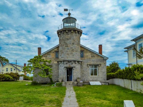

Croydon, London: Croydon Minster, the Old Palace, Shirley Windmill and Airport House
Croydon, England
Pictures from Croydon
See all 1 photos →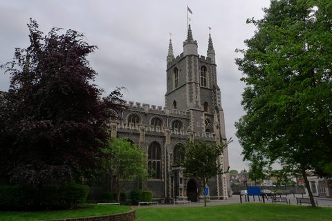
Croydon is an outer London borough, and it reads as four places rather than one. The town centre and Old Town hold the medieval seat of the archbishops of Canterbury, the Old Palace and Croydon Minster, with the Museum of Croydon inside the Croydon Clocktower and a street market running down Surrey Street. East of the town the tram runs out to Addington and Shirley, to a Georgian house in a registered landscape of 133.80 hectares, a village church of about 1080 and a working brick tower mill. The northern ridge at Upper Norwood and South Norwood carries a Victorian pleasure-ground, an Edwardian arts complex built by one man and a football ground of 1924. South along Purley Way stands the terminal of Croydon Airport, and above it chalk downland the City of London Corporation has held since 1883. The National Heritage List for England records 180 listed-building entries inside the borough boundary.
-
sight
Grade I as NHLE 1079319, with an inception of 1450 on Wikidata; the Minster states that it keeps the building open during the day to pray, sit, rest or be still.
-
tour
Eight Grade I entries since 11 June 2025, the Great Hall NHLE 1079296 among them; the buildings house a school and access is by pre-booked tour.
-
sight
A Grade I quadrangle, NHLE 1188846, standing on the pedestrianised North End shopping street opposite the Whitgift Centre.
-
sight
Free to visit and open Wednesday to Saturday from 10am, excluding Bank Holidays, inside the Grade II Croydon Clocktower, NHLE 1188798.
-
food
A street market running downhill from the High Street to Church Street, with The Dog and Bull, NHLE 1079273, and The Ship, NHLE 1079290, at its two ends.
-
sight
The archbishops' second seat, Grade II* NHLE 1358819, in grounds registered at 133.80 hectares as NHLE 1000790 and now a golf club.
-
Grade I, NHLE 1079343, with an inception of 1080 on Wikidata; Addington Village tram stop is 202 m away.
-
A brick tower mill, Grade II NHLE 1079277, open 12 noon to 5pm on 7 June, 5 July, 2 August, 6 September, 20 September and 4 October 2026.
-
Grade II, NHLE 1189018, 447 m from Shirley Windmill along Upper Shirley Road, with the Ruskin family monument, NHLE 1358824, in the churchyard.
-
walk
A registered landscape of 13.63 hectares, NHLE 1000823, that Historic England attributes to Croydon and Lambeth together, around a Grade II house.
-
sight
The Stanley Halls, Grade II NHLE 1252932, designed and funded by William Ford Robinson Stanley and opened on 2 February 1903, his birthday.
-
sight
The ground of Crystal Palace F.C., opened on 30 August 1924 to a design by Archibald Leitch, capacity 25,194, and in Croydon rather than Crystal Palace Park.
-
Grade II, NHLE 1079271, standing on Station Road 122 m from Norwood Junction, with Kennedys Sausages, NHLE 1392596, 139 m off.
-
sight
The 1926-28 terminal and control tower of Croydon Airport, Grade II* NHLE 1188970, with a De Havilland Heron on the forecourt.
-
walk
A scheduled monument of 46.21 hectares, NHLE 1002013, over a prehistoric field system and an Anglo-Saxon barrow cemetery, held by the City of London Corporation.
-
Eleven surviving blast pens on Kenley Common, covered by two scheduled monuments, NHLE 1021242 and NHLE 1021243, both entered on 6 September 2004.
-
walk
A street registered as a Grade II park and garden of 1.02 hectares, NHLE 1431287, with its Grade II war memorial, NHLE 1431367, standing in it.
Croydon town centre and Old Town
A medieval archbishops' seat sits inside a 1960s office city, a few hundred metres west of the tram tracks. Croydon Minster stands on Church Street, CR0 1RN, and is Grade I listed as NHLE 1079319, first listed on 29 January 1951 under the list entry name Parish Church of St John the Baptist. Wikidata records an inception of 1450. The Minster states that it keeps this historic building open during the day as a place where people can come to pray, sit, rest or just ponder and be still. The War Memorial at Croydon Minster in the churchyard is a separate Grade II entry, NHLE 1442680, and the church gateway on Howley Road, 124 m south, is a scheduled monument, NHLE 1002004, which carries no grade.
The Old Palace of the Archbishops of Canterbury, on Old Palace Road, CR0 1AX, was their summer residence for five centuries. Historic England first listed the Great Hall at Grade I on 29 January 1951 as NHLE 1079296 and amended the entry on 11 June 2025, splitting the palace into eight separate Grade I entries: the Great Hall, the Chapel (NHLE 1493512), the great chamber and undercroft range (1493514), the southern range including the long gallery (1493515), the western range (1493516), the east range of the north court (1493517), the east range of the south court (1493518) and the west range of the south court (1493519). Those eight account for eight of the fourteen Grade I entries in the borough. The buildings are occupied by Old Palace of John Whitgift School and access is by pre-booked tour; no source states a schedule of opening hours, so none are given here.
The Whitgift Almshouses stand on the pedestrianised North End shopping street at CR0 1PA, opposite the Whitgift Centre. Historic England lists the quadrangle at Grade I as NHLE 1188846, first listed 29 January 1951 under the entry name Hospital of the Holy Trinity (Whitgift Hospital). The Whitgift School War Memorial at Haling Park, South Croydon CR2 6YT, belongs to the same foundation and is separately Grade II listed, NHLE 1442708. No source states the almshouses' opening hours, so none are given here.
The Museum of Croydon occupies part of the Croydon Clocktower on Katharine Street, CR9 1ET, a complex Grade II listed as NHLE 1188798, first listed 19 November 1973 and amended 18 April 1983, under the entry name 'Municipal Buildings, comprising the clock tower, public library, and Corn Exchange, and including the area balustrade which incorporates a war memorial and a statue of Queen Victoria'. The museum states that it is free to visit and open Wednesday to Saturday from 10am, excluding Bank Holidays: the Special Exhibition Galleries on Level 1 and the Riesco Gallery on Level 0 open Wednesday to Saturday 10.00 to 16.30, the Atrium Gallery on Level 0 Monday to Friday 09.00 to 18.00 and Saturday 09.00 to 17.00, and the Archives Research Room by appointment on Wednesday, Friday and Saturday 10.00 to 13.00 and 13.30 to 16.30 and on Thursday 10.00 to 13.00. The David Lean Cinema and Croydon Central Library share the site. Croydon War Memorial on the same Katharine Street frontage is separately Grade II* listed, NHLE 1268438, first listed 19 November 1973 and amended 27 July 2017; Wikidata names James Burford as its designer.
Surrey Street runs downhill from the High Street to Church Street between the Minster and the Clocktower, tying the two ends of the Old Town together, and OpenStreetMap tags it as a marketplace. Two Grade II listed public houses stand at its opposite ends: The Dog and Bull, NHLE 1079273, first listed 29 January 1951 and amended 15 February 1983, at the Church Street end, and The Ship, NHLE 1079290, first listed 19 November 1973, at the High Street end. The Surrey Street Pumping Station, NHLE 1079248, and the Surrey Street Drinking Fountain and wall, NHLE 1495291, are both Grade II and both stand on the street; Historic England's description of the pumping station records four build phases, an engine house of 1851 probably by Thomas Cox, a second of 1867 by Baldwin Latham, an extension of 1876-7 designed by Thomas Walker and built by Smith of South Norwood, and a further extension of 1912. No source states the market's trading hours, so none are given here.
Addington, Shirley and the eastern tram villages
The eastern half of the borough is chalk and woodland, and the tram is the rail-mode service that reaches it. Addington Palace stands on Gravel Hill, CR0 5BB, and was the archbishops of Canterbury's second seat. Historic England lists the house at Grade II* as NHLE 1358819, first listed 29 January 1951, and registers the grounds separately as a Grade II park and garden, NHLE 1000790, entered on 1 October 1987 at 133.80 hectares. Lion Lodge and its gate piers, at the Addington Village end of the estate drive, are Grade II listed as NHLE 1358812. The estate is now Addington Palace Golf Club and the house is a private events venue; no source states public opening hours, so none are given here.
The Church of St Mary the Blessed Virgin stands on Addington Village Road, CR0 5AS, 86 m from the nearest boundary of that registered park. It is Grade I listed as NHLE 1079343, first listed 29 January 1951 under the entry name Church of St Mary Addington, and Wikidata gives an inception of 1080. The churchyard walls along the south boundary are separately Grade II listed, NHLE 1079344, and the Addington War Memorial in the churchyard is Grade II, NHLE 1442757. Flint Cottage, NHLE 1079345, and Addington House, NHLE 1079311, both Grade II, stand in the same village cluster. No source states the church's opening hours, so none are given here.
Shirley Windmill stands in Postmill Close, CR0 5DY, and is Grade II listed as NHLE 1079277, first listed 29 January 1951 under the statutory address Shirley Windmill, Upper Shirley Road. The operator records that William Alwen built a post mill on the site in 1808 and that fire destroyed it in October 1854; his grandson Richard built the present brick tower mill, which the Alwen family worked until the late 1880s. Alfred Rayson bought it and used it for animal feed until his death in 1892, when milling was abandoned, and lightning struck the mill in 1899 and again in 1906. It has two pairs of millstones, and the operator states that the original machinery has recently been restored, that Croydon Council owns, maintains and repairs the mill, and that The Friends of Shirley Windmill staff and manage it on open days. The 2026 open days are 7 June, 5 July, 2 August, 6 September, London Open House Day on 20 September and 4 October, each 12 noon to 5pm; the National Mills Day date of 10 May is cancelled for want of volunteers. The operator reports 1,037 visitors across the 2025 season and 29,612 since open days began in 1995.
The Church of St John the Evangelist stands on Shirley Church Road, CR0 5EF, 447 m from the windmill along Upper Shirley Road. It is Grade II listed as NHLE 1189018, first listed 29 November 1976 under the entry name Church of St John, and it is a different building from the Grade I Church of St John the Evangelist at Coulsdon, NHLE 1188464. Two churchyard monuments are separately Grade II listed and both were first listed on 15 February 1983: the monument to the parents of John Ruskin in the south-east corner, NHLE 1358824, and the monument to members of the Preston family in the north-west corner, NHLE 1079304. Shirley Vicarage beside the church is Grade II listed, NHLE 1189029, first listed 9 October 1981. No source states the church's opening hours, so none are given here.
Upper Norwood, South Norwood and Selhurst
The high northern ridge grew up around the relocated Crystal Palace, and the park itself is not Croydon's: its registered landscape entry, NHLE 1000373, gives District: Bromley (London Borough), and the terraces, the dinosaurs and Crystal Palace station stand outside the Croydon boundary. Croydon reaches the Crystal Palace triangle at Westow Hill and Westow Street, where the former Kennedy shop at 20 Westow Hill, NHLE 1477546, and the Westow Street war memorial, NHLE 1442618, are Grade II listed.
Norwood Grove is entered from Gibsons Hill, Norbury, SW16 3EF. The grounds are a Grade II registered park and garden, NHLE 1000823, entered on 1 October 1987 at 13.63 hectares, and Historic England attributes that entry to two authorities, Croydon and Lambeth, because the site sits astride the ridge the boundary follows. The house, known locally as The White House, is separately Grade II listed as Norwood Grove, Including Terrace Steps to Garden, NHLE 1079286, first listed 29 January 1951, and Historic England attributes that entry to Croydon alone. Croydon holds three registered parks and gardens in all: Addington Palace, NHLE 1000790, Norwood Grove, and the Promenade de Verdun at Purley, NHLE 1431287. The grounds are a public park; no source states opening hours for them, so none are given here.
Stanley Arts occupies the Stanley Halls at 12 South Norwood Hill, SE25 6AB, Grade II listed as Stanley Technical High School and Stanley Halls, NHLE 1252932, first listed 2 April 1989 and amended 4 October 2023. The venue records that William Ford Robinson Stanley, a prominent local inventor, industrialist and philanthropist, designed and funded the halls himself; that he employed the local builder Alfred Lawrence to construct the main hall in 1902; and that the first hall opened on 2 February 1903, Stanley's birthday, at a cost to him of £13,000, with the opening performed by the local MP Lord Ritchie, Chancellor of the Exchequer. The smaller adjoining halls, the committee room, the kitchen and the clock tower date from 1904, and the Stanley Art Club and its gallery from 1908. No source states a weekly opening schedule, so none is given here.
Selhurst Park, the home ground of Crystal Palace F.C., stands off Whitehorse Lane at SE25 6PU. The Lord Mayor of London opened it on 30 August 1924, Archibald Leitch designed it, and its capacity is recorded at 25,194. Despite the club's name the ground is not in Crystal Palace Park: the stadium stands in the London Borough of Croydon, its SE25 6PU postcode falls in Croydon's South Norwood ward, and it takes its name from adjoining Selhurst. It does not appear on the National Heritage List for England.
South Norwood Clock Tower stands on Station Road, SE25 6XP, 122 m from Norwood Junction station. It is Grade II listed as NHLE 1079271, first listed 15 February 1983 under the entry name Clock Tower, Station Road, and Wikidata records it as Q26351342. Kennedys Sausages, 139 m off, is Grade II listed as NHLE 1392596, first listed 21 May 2008, and Stanley Arts stands 256 m away.
Purley Way, Purley and the southern downs
Purley Way is the arterial road that runs past the former Croydon Airport, and above it the ground rises into open chalk downland. Airport House, the terminal and control tower at Purley Way, CR0 0XZ, is Grade II listed as NHLE 1188970, first listed 1 August 1978 and amended 5 May 2017. Historic England's reasons for designation describe an integrated airport terminal building and control tower, 1926-28 by the Air Ministry Department of Buildings and Works, listed at Grade II partly for its historic interest as an example of the first wave of purpose-built airport terminals and as Britain's first international airport, which is Historic England's own phrase. The record carries fifteen national grid references across the terminal and control tower group. The Former Lodge to Croydon Airport Terminal is separately Grade II listed, NHLE 1079299, first listed the same day, and the Grade II diving stage of the former Purley Way Lido, NHLE 1412916, listed 21 March 2013, stands 266 m away; two further Grade II Purley Way frontages of the airport era, 335-347 Purley Way, NHLE 1188899, and 351 Purley Way, NHLE 1079298, stand 1,593 m and 1,568 m off. OpenStreetMap records a De Havilland Heron displayed on the forecourt. The building is in office use with a volunteer-run visitor centre; no source states its opening days, so none are given here.
Farthing Downs is reached from Ditches Lane, Coulsdon, CR5 1DF, and is a scheduled monument, NHLE 1002013, first scheduled 29 November 1932 under the entry name 'Regular aggregate field system, associated trackway and Anglo-Saxon barrow field on Farthing Downs, 490m east of Hooley Farm'. As a scheduled monument it carries no grade. Historic England records the scheduled area at 46.21 hectares, combining a prehistoric field system, a trackway and an Anglo-Saxon barrow cemetery on one open chalk ridge. The downs lie in the London Borough of Croydon, and the City of London Corporation holds them as one of the four Coulsdon Commons, alongside Coulsdon Common, Kenley Common and Riddlesdown; its own heritage page states that the site was acquired by the City of London in 1883. That page dates the scheduling to 1948, following excavations by Brian Hope-Taylor, while the National Heritage List gives 29 November 1932 as the date first scheduled and is the register of record. Newe (or Wide) Ditch on Riddlesdown Common, CR8 1BH, is a second scheduled monument, NHLE 1005553, first scheduled 9 May 1951.
The surviving blast pens of RAF Kenley stand on Kenley Common, Hayes Lane, Kenley, CR8 5EU. Two scheduled monuments cover them, both first scheduled on 6 September 2004: a group of four World War II fighter pens, NHLE 1021242, over 0.76 hectares, and a group of seven, NHLE 1021243, over 1.16 hectares. The seven-pen record carries seven distinct national grid references, one per pen, and as scheduled monuments neither entry carries a grade. Kenley Common is a second of the four Coulsdon Commons held by the City of London Corporation, and the airfield is still partly in aviation use. OpenStreetMap records an RAF Kenley Tribute memorial and a Croydon Battle of Britain RAF Memorial in the borough.
The Promenade de Verdun on the Webb Estate at Purley, CR8 3LN, is a whole street laid out and registered as a First World War commemorative avenue rather than a park: a Grade II registered park and garden, NHLE 1431287, entered on 18 February 2016 over 1.02 hectares, for which Historic England gives the address as Woodcote, Purley. The Promenade de Verdun War Memorial standing in it is separately Grade II listed, NHLE 1431367, and the Grade II Woodcote War Memorial, NHLE 1442707, stands 466 m away.
Getting there
Croydon has no Underground station, no DLR station and no Elizabeth line station. Everything on rails in the borough is National Rail — Southern, Southeastern, Thameslink and Gatwick Express — the Overground's Windrush line, or the tram, which TfL London Trams operates as Tramlink.
East Croydon is the borough's main interchange, taking Southern, Southeastern, Thameslink, Gatwick Express and the tram. West Croydon takes Southern, the Overground Windrush line and the tram. Norwood Junction takes Southern, Southeastern, Thameslink and the Windrush line. The Overground reaches two stations in the borough, West Croydon and Norwood Junction, both on the Windrush line. Twenty-six named tram stops stand inside the boundary — Addington Village, Addiscombe, Ampere Way, Arena, Blackhorse Lane, Centrale, Church Street, Coombe Lane, East Croydon, Fieldway, George Street, Gravel Hill, Harrington Road, King Henry's Drive, Lebanon Road, Lloyd Park, New Addington, Reeves Corner, Sandilands, Tamworth Road / Centrale, Therapia Lane, Waddon Marsh, Wandle Park, Wellesley Road, West Croydon and Woodside — and the same network runs on into Bromley, Merton and Sutton.
For the town centre and Old Town, Church Street tram stop is 195 m from Croydon Minster and Reeves Corner 378 m. George Street tram stop is 139 m from the Whitgift Almshouses and 221 m from the Croydon Clocktower, with Wellesley Road 388 m and Church Street 418 m from the Clocktower and George Street 270 m from the middle of Surrey Street. West Croydon is 658 m from the almshouses, and East Croydon roughly 700 m from the Clocktower.
For Addington and Shirley, take the tram. Addington Village is 202 m from the Church of St Mary the Blessed Virgin and 515 m from Addington Palace; Gravel Hill is 350 m from the palace; Coombe Lane is 992 m from Shirley Windmill and 1,447 m from the Church of St John the Evangelist, with Sandilands 1,844 m from the windmill. TfL lists no National Rail, Overground, Underground or DLR station within 2.5 km of any of those three, and the windmill's operator gives its own distance as about 2 miles from East Croydon station.
For Upper Norwood, South Norwood and Selhurst, Norwood Junction is 122 m from South Norwood Clock Tower, 332 m from Stanley Arts and 688 m from Selhurst Park. Selhurst, on Southern, is 714 m from the ground and Thornton Heath, also on Southern, 1,066 m. Norbury, on Southern, is 1,005 m from Norwood Grove. Harrington Road tram stop is 1,079 m from the clock tower and 991 m from Stanley Arts. Crystal Palace station, 652 m from the Crystal Palace triangle, is in Bromley and serves the Upper Norwood end of the borough.
For Purley Way and the southern downs, Waddon, on Southern, is 1,269 m from Airport House, Purley Oaks 1,607 m, South Croydon, which takes Southern, Thameslink and Gatwick Express, 1,810 m and Wandle Park tram stop 1,954 m. Coulsdon South, on Southern and Thameslink, is 1,317 m from the centre of the Farthing Downs scheduled monument, NHLE 1002013, with Woodmansterne 2,018 m and Coulsdon Town 2,023 m. Reedham, which TfL names Reedham (Surrey) Rail Station to distinguish it from Reedham in Norfolk but which stands in the London Borough of Croydon at CR8 4EU, is 1,093 m from the Promenade de Verdun, and Purley, on Southern and Thameslink, is 1,529 m. The two nearest stations to the Kenley fighter pens are Whyteleafe, 1,084 m, and Whyteleafe South, 1,387 m, both served by Southern and both outside Greater London in Tandridge, Surrey; Kenley station, also on Southern, is 2,008 m. Every distance above is a straight-line approximation, not a walking measurement.
Frequently asked questions
- Does Croydon have an Underground station?
- No. The borough has no Underground station, no DLR station and no Elizabeth line station. East Croydon is served by Southern, Southeastern, Thameslink, Gatwick Express and the tram; West Croydon by Southern, the Overground Windrush line and the tram; and Norwood Junction by Southern, Southeastern, Thameslink and the Windrush line, which are the two Overground stations in the borough. Twenty-six named tram stops stand inside the boundary, and TfL London Trams runs the same network on into Bromley, Merton and Sutton.
- Can you go inside the Old Palace of the Archbishops of Canterbury?
- The buildings on Old Palace Road, CR0 1AX, are occupied by Old Palace of John Whitgift School, and public access is by pre-booked tour rather than open hours; no source states a schedule, so none is given here. Historic England first listed the Great Hall at Grade I on 29 January 1951 as NHLE 1079296 and amended the entry on 11 June 2025, when the palace was divided into eight Grade I entries — the Great Hall plus NHLE 1493512, 1493514, 1493515, 1493516, 1493517, 1493518 and 1493519.
- When is Shirley Windmill open?
- The Friends of Shirley Windmill run open days at Postmill Close, CR0 5DY, from 12 noon to 5pm. The 2026 dates are 7 June, 5 July, 2 August, 6 September, London Open House Day on 20 September and 4 October; the National Mills Day date of 10 May is cancelled for want of volunteers. The mill is Grade II listed as NHLE 1079277 and has two pairs of millstones; Croydon Council owns and maintains it, and the Friends staff and manage it on open days. Coombe Lane tram stop is 992 m away.
- How many listed buildings and scheduled monuments does Croydon hold?
- The National Heritage List for England records 180 listed-building entries with a point inside the borough boundary — 14 at Grade I, 9 at Grade II* and 157 at Grade II — along with 8 scheduled monuments and 3 registered parks and gardens, 191 designations in total. The count is of list entries rather than of buildings: a multi-part entry such as Airport House, NHLE 1188970, which carries fifteen national grid references, counts once. Eight of the fourteen Grade I entries are the eight parts of the Old Palace, separated by Historic England on 11 June 2025.
- Is Crystal Palace Park in Croydon?
- No. Its registered park and garden entry, NHLE 1000373, gives District: Bromley (London Borough), and the terraces, the dinosaurs and Crystal Palace station all stand outside the Croydon boundary. Croydon's boundary reaches the Crystal Palace triangle at Westow Hill and Westow Street, where the former Kennedy shop at 20 Westow Hill, NHLE 1477546, and the Westow Street war memorial, NHLE 1442618, are Grade II listed. Selhurst Park, the home ground of Crystal Palace F.C., is in Croydon at SE25 6PU.
- What are the Museum of Croydon's opening hours, and does it charge?
- The museum, in the Croydon Clocktower at Katharine Street, CR9 1ET, states that it is free to visit and open Wednesday to Saturday from 10am, excluding Bank Holidays. The Special Exhibition Galleries on Level 1 and the Riesco Gallery on Level 0 open Wednesday to Saturday 10.00 to 16.30, the Atrium Gallery on Level 0 Monday to Friday 09.00 to 18.00 and Saturday 09.00 to 17.00, and the Archives Research Room by appointment on Wednesday, Friday and Saturday 10.00 to 13.00 and 13.30 to 16.30 and on Thursday 10.00 to 13.00. The building is Grade II listed as NHLE 1188798, and George Street tram stop is 221 m away.
Connected pages
Nearby
-
Bromley, London: Crystal Palace Park and its dinosaurs, Down House, Chislehurst Caves and Keston Windmill
· Bromley, England
Crystal Palace Park, NHLE 1000373, and its dinosaurs are Bromley's; Selhurst Park, the ground of the club named for the palace, stands in Croydon.
Shared history
-
Lambeth, London: the South Bank, Lambeth Palace, Brixton Market and West Norwood Cemetery
· Lambeth, England
The archbishops held Lambeth Palace on the river and the Old Palace at Croydon; Norwood Grove, NHLE 1000823, adjoins Lambeth's Streatham Common.
-
Lewisham, London: St Paul's Deptford, the Horniman Museum and Beckenham Place Park
· Lewisham, England
The Croydon Canal ran from West Croydon to the Grand Surrey Canal, and its line is now the railway through Honor Oak and Forest Hill in Lewisham.
Same region
-
Merton, London: Wimbledon Common and the windmill, the All England Club, Merton Priory and Morden Hall Park
· Merton, England
The Wandle's other head rises at Waddon in Croydon: two boroughs' springs, one river, and Merton's priory, mills and snuff works stand downstream of both.
-
Sutton, London: Carshalton Ponds, Honeywood Museum, Whitehall in Cheam, Carew Manor and Little Holland House
· Sutton, England
The Wandle has two heads, Carshalton and Beddington in Sutton and Waddon in Croydon, and the tram line from Beddington Lane runs on into Croydon.
What travelers think
Log in to react.
No reviews yet.